Soil Profiles: Jawa
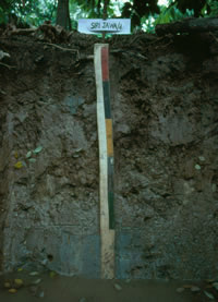
Jawa Series
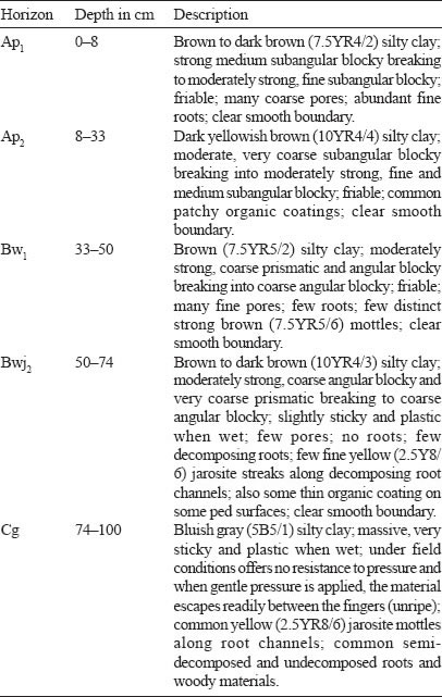
The Jawa Series is a member of the Jawa Family which is a fine, mixed, isohyperthermic, brown Sulfik Tempajelahs. It typifies this family which is developed over brackish water deposits. These soils have a brown to dark brown silty clay surface horizons which grades into a yellowish brown to brown silty clay B horizons having moderate medium and fine subangular blocky structures and friable consistence. In the lower part of the B horizon below 50 cm depth a sulfuric horizon with jarosite mottles occurs. The bluish gray to grey massive marine clay which is unripe occurs below the sulfuric horizon. In this C horizon jarosite mottles may occur along old root traces.
Type Location
The Jawa Series was first established by Paramananthan (1975) during the survey of Phase I of Johor Barat. Such soils were earlier mapped as Selangor Series shallow phase. The above pedon was described by Noordin Daud (1980) on Sabrang Estate south of Telok Anson, Perak. Location: Topographic Sheet 3460, 4°01’50” N, 100°56’20” E (Grid Reference 3460 – 292463 m).
Range in Characteristics
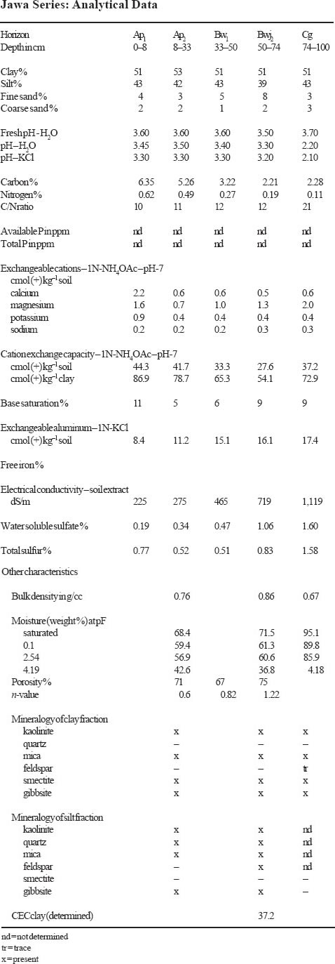
The Jawa Series may have a surface horizon which is organic but it does not exceed 20 cm and very often the material is sapric. Like many of the other man-made soils, the degree of decomposition depends on the intensity and the length of time the area has been drained. However very often the surface horizon is mineral. The A horizons in the Jawa Series range in colour from black to dark brown, dark grayish brown to dark gray (10YR2/1, 3/3, 4/1, 4/2, 4/3; 7.5YR3/ 2, 4/2, 4/4) and are humic clay, silty clay or clay with moderate to strong medium and fine subangular blocky structures. The B horizons are usually dark brown, brown, dark grayish brown to grayish brown (10YR3/3, 4/2, 4/3, 5/2, 5/3 and 7.5YR4/2) silty clay to clay often rich in organic carbon. Structures in the upper part of the B horizon depending on the drainage ranges from weak coarse angular blocky to strong, medium and fine subangular blocky. Below 50 cm the grade of structure decreases and becomes weak to moderate medium to coarse angular blocky or even prismatic. Consistence is friable in the upper part of the soil but becomes sticky with depth. Mottling is mainly confined to old root channels and ranges from common fine to medium, distinct strong brown (7.5YR5/6–5/8) and few fine distinct reddish yellow (7.5YR6/6–6/8). Below 50 cm depth yellow (2.5Y8/6) jarosite mottles occur mainly along old root traces. The underlying unripe marine deposit is a greenish gray, dark greenish gray or bluish gray (5GY4/1, 5/1, 6/1, 5G4/1, 5/1, 6/1; 5BG4/1, 5/1, 6/1) silty clay to clay which may or may not have jarosite mottles along old root channels. This marine deposit may be encountered either within 100 cm or below 100 cm. Some buried wood is a common feature in this deposit.
Competing Soils and Their Differences
The Jawa Series may be confused with soils of the Sedu, Parit Botak, Tongkang (A), Perepat, Sabrang and Selangor Series. The Sedu and Parit Botak Series have a sulfuric horizon within 50 cm while the Jawa Series between 50 to 100 cm. The Tongkang Series also has a sulfuric horizon between 50 and 100 cm but it has light gray matrix colours, coarser structures and sticky consistence. Both the Perepat and Sabrang Series do not have a sulfuric horizon. The Perepat Series also has light gray colours. The Sabrang Series has almost all features similar to that of the Jawa Series except that a sulfuric horizon is not present in the case of the Sabrang Series. The Jawa Series which have the marine clay below one metre may be confused with that of the Selangor Series because both have friable, brown B horizons. However the Selangor Series either does not have jarosite or if present the sulfuric horizon only occurs below one metre. The underlying marine clay of the Jawa Series is often sulfidic but even if it was not sulfidic the soil is currently placed with the Jawa Series due to the overlying sulfuric horizon. No true acid sulfate soils have been mapped in Sabah and Sarawak to-date as potential acid sulfate soils have only been recently drained. In Sabah, soils of the Bergosong Family (Thionic-Humic Gleysols) when drained may developed into the Jawa Series if the sulfuric horizon occurs between 50–100 cm depth. In Sarawak, soils of the Kluang Series are only potential acid sulfate soils with sulfidic materials between 50–100 cm depth. More data is required to correlate these soils.
Setting
Soils of the Jawa Series form a sequence with soils of the Sedu and Selangor Series. The Sedu Series is characterized by having a sulfuric horizon within 50 cm of the surface while the Jawa between 50 to 100 cm and the Selangor does not have a sulfuric horizon to 100 cm. These soils occur in areas on the coastal plain where they grade into a peat swamp.
Principal Associated Soils
The Jawa Series since it forms a sequence with the Selangor and Sedu Series is often associated with both these soils. These three soils only differ in the depth at which the sulfuric horizon occurs. The Jawa Series may often also be associated with other non-acid sulfate soils such as the Serkat and Sabrang Series. Both these soils only have a cambic horizon overlying the marine clay at different depths.
Drainage and Permeability
The Jawa Series soils are somewhat poorly drained soils. They often have the permanent groundwater table around 50–100 cm. Above this marine clay horizon the B horizon has fairly good permeability.
Use and Vegetation
The Jawa Series is a man-made soil as it is formed by artificial drainage. These soils have been mapped in the past as Selangor Series (shallow phase). These soils are currently cultivated to oil palm, coconut, cocoa, and coffee. Although pineapple, coffee and rubber may have been planted in the past these are slowly being replaced with oil palm.
Distribution and Extent
Most of the areas mapped as Selangor (shallow) have now been reclassified into many soils including the Jawa, Sedu, Serkat and Sabrang Series. It is therefore difficult at this stage to determine the actual extent of these soils. These soils have to-date been identified in the Kerian and Telok Anson areas of Perak, in Selangor, in Malacca, Johor and also in Pahang.
Series Established
The Jawa Series was first established during the semi-detailed soil survey of Johor Barat. The source of the name is the village of Parit Jawa, in Johor.
Remarks on Classification
The Jawa Series is classified here according to the Malaysian Soil Taxonomy – Second Approximation (Paramananthan 1998) as a member of the fine, mixed, isohyperthermic, brown family of SULFIK TEMPAJELAH. These are poorly drained soils which have brown coloured B horizons and a sulfuric horizon between 50 to 100 cm depth. In the Keys to Soil Taxonomy – Eighth Edition (Soil Survey Staff 1998) the Jawa Series would probably be classified as Sulfic Endoaquepts. In the FAO/ UNESCO Soil Map of the World – Revised Legend (FAO 1990) this soil would be classified as Thionic Fluvisols.
Suitability for Agriculture
Crops which only require about 50 cm of soil such as cash crops can be readily cultivated on this soil. Oil palm can also be grown on this soil with good management – especially water control to keep the sulfuric horizon moist. Coconut and coffee should also do well on these soils. Cocoa however is only expected to be marginal on these soils.
Soil Profiles: Jarangan

Jarangan Series
The Jarangan Series is a member of the Munchong Family which is a very fine, kaolinitic, isohyperthermic, red-yellow Tipik Tempalemoks. It is developed over fine grained basic igneous rocks such as basalts. Soils of the Jarangan Series are characterized by their deep heavy clay textured oxic horizons with yellowish brown or strong brown colours at 50 cm depth. These oxic horizons have an ECEC of more than 1.5 cmol (+) kg–1 clay. Structures are weak medium to fine subangular blocky and consistence is friable

Type Location
Soils of the Jarangan Series were first established by Paton (1963) during the Reconnaissance Soil Survey of the Semporna Peninsula. The above pedon was described by staff of the Department of Agriculture Sabah in the Quoin Hill Agricultural Research Station near Tawau on undulating terrain (4–12% or 2– 6° slopes) at an elevation of 60 m (180 feet). Location: Topographic Sheet 4/118/ 9, 4°03’00” N, 118°01’30” E (Grid Reference 4/118/9 – 914836 m).
Range in Characteristics
Little is known about the range in characteristics of this soil. The colours range from yellowish brown to brownish yellow (10YR5/6, 5/8, 6/6, 6/8) to strong brown (7.5YR5/6, 5/8). Textures are uniformly clayey with more than 60% clay with some few fine clear quartz grits. The structures are weak medium to fine subangular blocky and consistence is friable. Soils of the Jarangan Series are deep (> 100 cm depth) and are well drained. Chemically as these soils are defined here they must have an ECEC of more than 1.5 cmol (+) kg–1 clay but less than 16 cmol. These soils have an oxic horizon.
Competing Soils and Their Differences
Soils of the Jarangan Series can easily be mistaken for many other soils which have an oxic or kandic horizons with heavy clay textures and brownish yellow to strong brown colours such as the Jerangau, Senai, Munchong, Katong and Tangga Series which are soils with oxic horizons and the Lanchang and Chat Series which have kandic horizons. Soils of the Jerangau and Senai Series are developed over granodiorite and gabbro parent material respectively and have an ECEC of less than 1.5 cmol (+) kg–1 clay. The Munchong, Katong and Tangga Series are similar to the Jarangan Series but are developed over shale, quartz andesite and limestone respectively. Both the Lanchang and Chat Series have a kandic horizon.
Setting
Soils of the Jarangan Series typically occur on undulating, rolling to hilly terrain (4–38% or 2–20° slopes) at elevations of less than 200 m (600 feet).
Principal Associated Soils
Soils of the Jarangan Series have till now been only mapped in the Tawau- Semporna and Telupid areas in Sabah. Being developed over intermediate to basic igneous rocks they have been mapped in association with soils of the Table, Apas and the Pinianakan Series. These soils are differentiated from the Jarangan Series using the colour and the parent material.
Drainage and Permeability
Soils of the Jarangan Series are generally well drained and have a rapid permeability.
Use and Vegetation
In the Tawau area in Sabah, where these soils have been mapped, these soils are mainly under oil palm and cocoa. Small areas are under primary forest.
Distribution and Extent
The Jarangan Series has to-date been only mapped in the Tawau and Telupid areas in Sabah. The actual extent of these soils is not known.
Series Established
This soil was established by Paton (1963) during the Reconnaissance Soil Survey of the Semporna Peninsula. The source of name is the Sungei Jarangan near Tawau.
Remarks on Classification
The Jarangan Series is classified here according to the Malaysian Soil Taxonomy – Second Approximation (Paramananthan 1998) as a member of the very fine, kaolinitic, isohyperthermic red-yellow family of Tipik Tempalemoks over basalt parent material. They are classified here as deep well drained soils that have heavy clay oxic horizons which have yellowish brown to strong brown colours and an ECEC of more than 1.5 cmol (+) kg–1 clay. In the Keys to Soil Taxonomy – Eighth Edition (Soil Survey Staff 1998), the Jarangan Series would probably be classified as Xanthic/Haplic Hapludox depending on the colour. In the FAO/UNESCO Soil Map of the World – Revised Legend (FAO 1990) the Jarangan Series would probably be classified as Xanthic/ Haplic Ferralsols depending on the colour.
Suitability for Agriculture
The main limitations for agriculture in these soils is the low fertility and the slope on which these soils occur. These soils should be suitable for a wide range of crops.

Soil Profiles: Gali
Gali Series
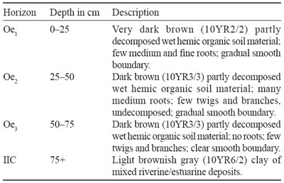
The Gali Series is a member of the Gali Family which is a riverine-clayey, dysic Hemik (Terrik) Topogamborgs. It typifies this family and is autochthonous, low-ash, non-woody. These are shallow to moderately deep (50–150 cm) organic soils which are found in narrow valleys and inland swamps often in areas with sedimentary rocks. They have a high water table (unless artificially drained) and terric or hemic material form the dominant material in the subsurface tier. The underlying mineral soils in these organic soils occur at depths between 50 to 150 cm and consists of clay of riverine or colluvial origin. These soils have a low ash content and are dysic in the surface tier. The organic materials in these soils are generally non-woody.
Type Location
Soils of the Gali Series were first proposed and established during the Semi-Detailed Soil Survey of the Terengganu River Basin (Biot et al. 1982) but no description and analytical data were available in that report. The above pedon was described in the Rompin area of Pahang in a swamp forest. Location: Topographic Sheet 4456, 2°43’27” N, 103°32’12” E (Grid Reference 4456 – 155018 m).
Range in Characteristics
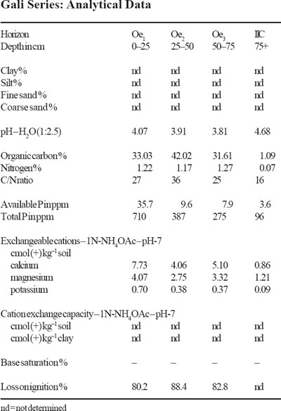
Little is known about the range in characteristics of the Gali Series. From what is known to-date the organic soil layer is dominantly hemic and non-woody and extends to a depth of 50 cm to 150 cm. The underlying mineral substratum is generally clayey (> 15% clay) and is alluvium/colluvium derived from sedimentary rocks. These soils can have a surface tier that is fibric, hemic and has a low ash content. Commonly the mineral soils are encountered below 75 cm depth.
Competing Soils and Their Differences
To-date a total of 18 soil series have been mapped as soils having shallow to moderately thick (50–150 cm) organic deposits. Of these only four soil series, namely the Bakri, Gali, Pak Bong and Tasik Series have hemic organic soil materials dominating the subsurface tier (50–100 cm). Both the Gali and Tasik Series are underlain by riverine/colluvial clays. Soils of the Gali Series are differentiated from the Tasik Series by the ash content in the surface tier. The Bakri Series has hemic materials in the subsurface tier but the underlying mineral material is marine-clayey and sulfidic.
Setting
Soils of the Gali Series are found in inland valleys or swamps found between hills of sedimentary rocks. Thus the underlying mineral soils are often clayey.
Principal Associated Soils
Little is known about the soils commonly associated with soils of the Gali Series. In the inland swamp situations these soils could be associated with other organic soils such as the Tasik, Pak Bong or Gadong Series. Where sedimentary rocks occur adjacent to the beach ridges these soils could occur close to the Igan, Mukah and Epai Series.
Drainage and Permeability
In their natural state soils of the Gali Series are permanently under water and are very poorly drained. When drained, shrinkage and decomposition of the organic materials takes place fairly rapidly. These soils may then no longer be classified as the Gali Series.
Use and Vegetation
In their natural state, soils of the Gali Series are mainly under sedges, grasses and shrub vegetation. Locally some of these areas have been drained and planted with vegetables.
Distribution and Extent
It is expected that soils of the Gali Series form small inland swamps in areas where sedimentary rocks form the hills. The actual distribution and extent is not known. To-date these soils have been mapped in Terengganu and locally in some other states.
Series Established
The Gali Series was first established in Terengganu, Peninsular Malaysia by Biot et al. (1982). It is not clear where the name was derived from.
Remarks on Classification
The Gali Series is classified here according to the Malaysian Soil Taxonomy – Second Approximation (Paramananthan 1998) as a member of the riverine- clayey, dysic family of Hemik (Terrik) Topogamborgs which is autochthonous, low ash, non-woody. They are classified as shallow to moderately deep (50–150 cm) organic soils in which hemic and terric materials dominate the subsurface tier (50–100 cm). The underlying mineral soil is riverine clayey (> 15% clay) and the organic layer is autochthonous and non-woody. The surface tier (0–50 cm) is both dysic and of low ash content. In the Keys to Soil Taxonomy – Eighth Edition (Soil Survey Staff 1998) this soil would be classified as Terric Haplohemists. In the FAO/UNESCO Soil Map of the World – Revised Legend (FAO 1990) this soil would probably be classified as Fibric Histosols.
Suitability for Agriculture
In their natural state, soils of the Gali Series are permanently under water and hence not suitable for agriculture. Once drained these soils can be used for the cultivation of vegetables, tapioca, sago and oil palm. However special management is required on these soils especially in relation to trace elements – copper, boron and zinc.
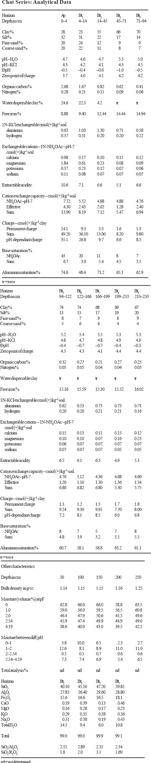
Soil Profiles: Chat
Chat Series
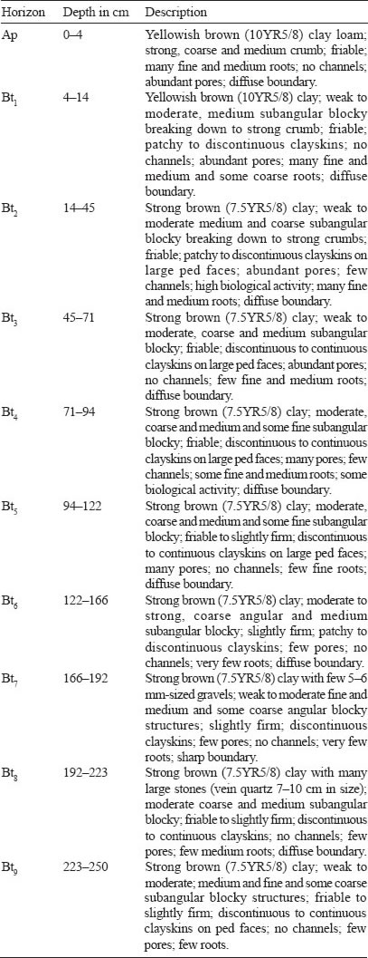
The Chat Series is a member of the Lanchang Family which is a very fine, kaolinitic, isohyperthermic, red-yellow Tipik Lutualemkuts. It is developed over fine grained sedimentary rocks. The soils have brown to yellowish brown clay to clay loam A horizons. The B horizons are deep and uniform with strong brown to yellowish brown colours and heavy clay textures. At depths below 70 cm the colours may become yellowish red. At depth, occasionally a layer of vein quartz may be present. The structures are weak to moderate, medium subangular blocky with friable consistence and patchy to discontinuous clayskins occur on ped faces. These soils have been identified over iron-rich shales sometimes having veins quartz. These soils have a kandic horizon and hence must have a CECclay of less than 16 cmol (+) kg–1 clay in all subhorizons between 25 to 100 cm depth. No significant clay decrease to 100 cm depth is permissible.
Type Location
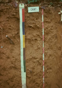
The Chat Series was first established by Lim (1977). The above pedon was from the type locality along a timber tract between Benta town and Kampong Chat near Jerantut, Pahang, on rolling topography (6–12°) at an elevation of about 80 metres (250 ft). Location: Topographic Sheet 3860, 3°58’50” N, 101°59’20” E (Grid Reference 3860 – 435395 m).
Range in Characteristics
The Chat Series was formerly mapped as the Munchong Series. In the past the Munchong Series included soils with both with an oxic as well as an argillic or kandic horizons. Those having a deep kandic horizon and predominantly strong brown colours are now reclassified as the Chat Series. These soils also must have a CECclay of less than 16 cmol (+) kg–1 clay in all subhorizons between 25 to 100 cm depth. The A horizons of the Chat Series have colours ranging from brown yellowish brown to dark yellowish brown (10YR4/4, 4/6, 5/3, 5/4, 5/6, and 7.5YR5/4) and clay to clay loam textures. The upper part of the B horizons of the Chat Series often has yellowish brown, strong brown and rarely reddish yellow colours (10YR5/6, 5/8; 7.5YR5/6, 5/8, 6/6, 6/8) and uniformly clay textures. Hues of 5YR may be permitted but cannot occur within 50 cm of the surface. Very often the strong brown colours (7.5YR5/8) colours extend uniformly to great depths. The clay contents in the B horizon average over 65% and increase slightly with depth. The structures in the B horizons are weak to moderate medium subangular blocky and consistence is friable. The structures become slightly stronger and consistence slightly firm with depth. A stoneline often of fine nodular petroplinthite and/or stones of vein quartz may be present at depths below 1.25 m. Clayskins which are often patchy in the upper but discontinuous in the lower part of the B horizon are a distinctive feature of these soils.
Competing Soils and Their Differences
The 10YR and 7.5YR hues of the Chat Series in the upper part of the B horizon distinguishes this soil from the Segamat, Prang, Kampong Kolam and other redder soils. The presence of an kandic horizon separates the Chat Series from the Munchong, Jerangau and Katong Series. The Lanchang Series has similar colours but appears to have more medium to coarse sand than the Chat Series as it is developed over granodiorite. The Yong Peng Series on the other hand has textures which are more silty. The Lanchang and Yong Peng are developed from igneous rocks – granodiorite and dacite respectively while the Chat from shales. A soil referred to by some surveyors as the Razak Series is similar to the Chat Series and is hence this name should no longer be used. The clay content of more then 60% separates the Chat Series from the Bungor, Bedup, Kumansi/deep and Serdang Series. The Ulu Dong Series has redder colours and has more than 60% clay. Soils of the Melugu, Stass and Padawan Series also have more than 60% clay but have CECclay values exceeding 16 cmol (+) kg–1 clay in some subhorizon within 25 to 100 cm depth.
Setting
Soils of the Chat Series have been mapped on undulating to hilly terrain. They have been mapped at elevations ranging from 15–100 m (50–300 ft).
Principal Associated Soils
The Chat Series is often associated with soils of the Munchong, Serdang, Malacca, Gajah Mati and Prang Series. The Serdang Series is developed over quartzites and sandstones and has sandy clay loam textures and brownish yellow to yellowish brown colours. The Malacca and Gajah Mati Series are characterized by a thick band of lateritic nodules occurring within 50 cm of the surface. The Prang Series has hues which are much redder (2.5YR and 5YR) within 50 cm of the soil surface and has an oxic horizon. The Bungor Series has a fine sandy clay texture with more fine sand, consistence is firmer and structures are better developed. The colours of the Bungor Series are also often yellower than that of the Chat Series.
Drainage and Permeability
Soils of the Chat Series are well drained and have a good permeability.
Use and Vegetation
Rubber, oil palm and fruit trees are the main crops grown on this soil. In parts of Pahang and Kelantan, some of these soils may still be under primary forests.
Distribution and Extent
The actual distribution of these soils is not known. However, it appears that many of the areas mapped as Munchong Series in the past may be Chat Series. These soils have so far been identified in Selangor, Pahang, Johore and Kelantan. They may also be present in Sabah and Sarawak.
Series Established
This soil was established near Kampong Chat just south of Benta town in Pahang. The source of name is Kampong Chat, Pahang, Peninsular Malaysia.
Remarks on Classification
The Chat Series is classified here according to the Malaysian Soil Taxonomy – Second Approximation (Paramananthan 1998) as a member of the very fine, kaolinitic, isohyperthermic, red-yellow family of Tipik Lutualemkuts. They are classified as soils have a thick kandic horizon in which the clay contents increases or remains constant to a depth of over 100 cm and have a CECclay of less than 16 cmol (+) kg–1 clay between 25 to 100 cm depth. In the Keys to Soil Taxonomy – Eighth Edition (Soil Survey Staff 1998) the Chat Series are probably Typic Kandiudults. In the FAO/UNESCO Soil Map of the World – Revised Legend (FAO 1990) these soils would be classified as Haplic Nitisols.
Suitability for Agriculture
The Chat Series appears to be a highly suitable soil for agricultural development. The terrain is probably the major limitation in these soils. In areas where droughts or low rainfall is experienced these soils can give rise to moisture problems particularly during the establishment of the crop.
Soil Profiles: Bungor
Bungor Series
The Bungor Series is a member of the Bungor Family which is a fine, kaolinitic, isohyperthermic, red-yellow Tipik Lutualemkuts. It typifies the family and is developed over mixed sedimentary rocks. These soils are characterized by dark greyish brown A horizons with fine sandy loam textures and deep B horizons having brownish yellow to yellowish brown colours and fine sandy clay textures. Consistence is friable and becomes firmer with depth. The structures are weak to moderate medium and fine subangular blocky. At depths below 75 cm few medium to coarse distinct red mottles may appear. At depths below 150 cm the colours become paler. This soils is developed over interbedded sandstones and shales or sandy shales. These soils have a kandic horizon and must have a CECclay of less than 16 cmol (+) kg–1 clay in all subhorizons between 25 to 100 cm depth. No significant clay decrease to 100 cm depth is permissible.
Type Location
The Bungor Series was first established on the western part of lower Sungei Lepar Valley in east Pahang by Libby (1964) during the Reconnaissance Soil Survey of Lepar Valley, Pahang. The above pedon was described on a 12° slope in undulating terrain near the village of Sri Jaya at the 37th milestone Kuantan- Temerloh Road. Location: Topographic Sheet 4259, 3°40’20” N, 102°52’40” E (Grid Reference 4259 – 426060 m).
Range in Characteristics
Soils of the Bungor Series show very little variation in the areas mapped to-date. They have colours which range from strong brown, brownish yellow and yellowish brown (7.5YR5/6; 5/8; 10YR5/6, 5/8, 6/6, 6/8). Rarely the colours may be reddish yellow (7.5YR6/6, 6/8). Textures range from fine sandy loam to fine sandy clay loam to clay. Clay contents seldom exceed 50% and fine sand always dominates the coarse sand which seldom exceeds 20%. Structures are weak to moderate medium and fine subangular blocky and consistence friable to firm with depth. Red mottles often appear at depths below 75 cm and increase with depth. The depth of the soil though often deep may sometimes be shallow on steep slopes as they grade into the Kuala Brang and Kuah Series. Some soils of the Bungor Series have a thin band of nodular petroplinthite but the band cannot exceed 25 cm in thickness. As defined here soils of the Bungor Series must have a CECclay of less than 16 cmol (+) kg–1 clay in all subhorizons between 25 to 100 cm depth.
Competing Soils and Their Differences
Soils of the Bungor Series are very similar to soils of the Serdang, Batang Merbau, Munchong Series and Jerangau Series. Both the Munchong and Jerangau Series may have similar colours to the Bungor Series but are heavier textured and have oxic horizons. The distinction between the Bungor Series and the Batang Merbau and Serdang Series is difficult. The Batang Merbau Series has a sand fraction dominated by medium sand while the Bungor Series is dominated by fine sand. The Bungor Series in the field does not show up any coarse sand and even the fine sand is so rounded that it is often not felt. The Serdang Series has fine sandy clay loam textures. The Batang Merbau Series also is reported to have mica flakes throughout the profile as it is developed over mica schists. Some of the Durian Series mapped in the past also may have 7.5YR hues but these have much siltier textures, redder colours at shallow depths, shallower profiles and very firm consistence. The Kuala Brang Series which has many features similar to the Bungor Series is a moderately deep equivalent of the Bungor Series and the saprolite is encountered within 100 cm. Soils of the Bungor Series can be easily mistaken for the Bedup Series (Sarawak) and Kumansi Series/deep (Sabah) or Merit Series (Sarawak) but these soils have a CECclay of more than 16 cmol (+) kg–1 clay in some subhorizon between 25 to 100 cm depth.
Setting
Soils of the Bungor Series are developed over interbedded sandstones and shales or sandy shales. They have been mapped over a wide range of terrain ranging from gently undulating to steep. The commonest range is undulating to hilly.
Principal Associated Soils
Soils of the Bungor Series have often been mapped in association with soils of the Serdang and Munchong Series. The Serdang Series has fine sandy clay loam textures, is more friable and weaker structured than the Bungor Series. The Munchong Series on the other hand is heavy clay textured, more friable and has an oxic horizon. As defined here soils of the Bungor Series may now be associated with soils of the Bedup, Kumansi/deep and Merit Series from which it can be differentiated using the CECclay values.
Drainage and Permeability
Soils of the Bungor Series are well drained and have a good permeability.
Use and Vegetation
Soils of the Bungor Series are commonly planted with a variety of crops including rubber, oil palm, fruit trees, cocoa. Some of these areas are still under primary forest vegetation.
Distribution and Extent
The Bungor Series is fairly well distributed in Peninsular Malaysia. It has been mapped in Perak, Selangor, Negeri Sembilan, Johore, Malacca, Pahang, Terengganu and Kelantan. Their extent is however not known.
Series Established
The soil was established during the Reconnaissance Soil Survey of the Lepar Valley, Northeast Pahang (Libby 1964). The source of name is the village of Paya Bungor on the Kuala Lumpur-Kuantan road.
Remarks on Classification
Soils of the Bungor Series are classified here according to the Malaysian Soil Taxonomy – Second Approximation (Paramananthan 1998) as a member of the fine, kaolinitic, isohyperthermic, red-yellow family of the Tipik Lutualemkuts. They have a deep kandic horizon which has a low base status and in which the clay content does not decrease significantly within 1.0 m of the surface. The CECclay is less than 16 cmol (+) kg–1 clay in all horizons between 25 to 100 cm depth. Soils of the Bungor Series would be classified as Typic Kandiudults in the Keys to Soil Taxonomy – Eighth Edition (Soil Survey Staff 1998). In the FAO/ UNESCO Soil Map of the World – Revised Legend (FAO 1990) they will be classified as Haplic Nitisols.
Suitability for Agriculture
These soils are some of the better sedentary soils found in Peninsular Malaysia. Terrain should be the major limiting factor in these soils. Their fertility status like most soils in this country is low.

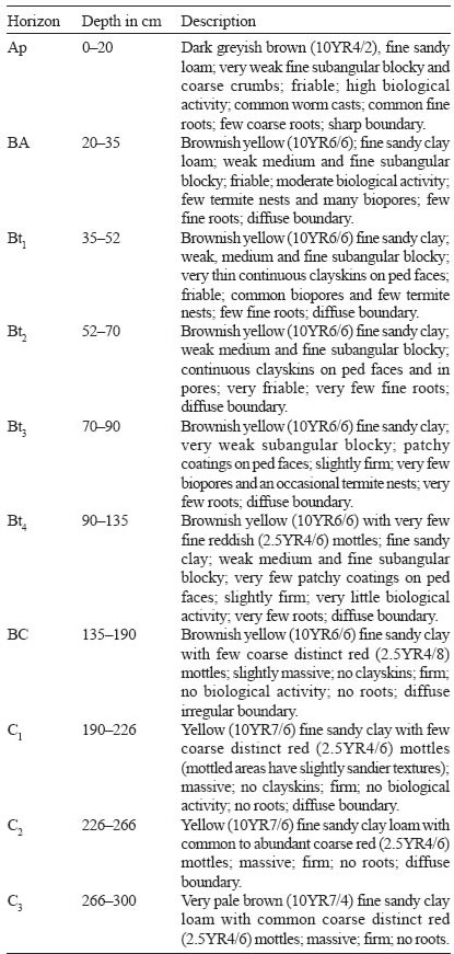
Soil Profiles: Bekenu
Bekenu Series
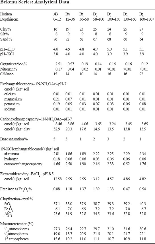
The Bekenu Series is a member of the Bekenu Family which is fine loamy, siliceous, isohyperthermic, red-yellow to yellow Tipik Tualemkuts. It typifies the family and is developed over mixed sedimentary rocks. Soils of the Bekenu Series are redefined here as being characterized by their deep, well drained profiles with brownish yellow to yellow subsoil colours dominating the subsoil. These soils have an argillic horizon with fine sandy clay loam textures and a ECECclay of less than 24 cmol (+) kg–1 clay in all subhorizons between 25 to 100 cm depth. Structures are weak medium to coarse subangular blocky and consistence is friable. Patchy clayskins occur on ped faces.
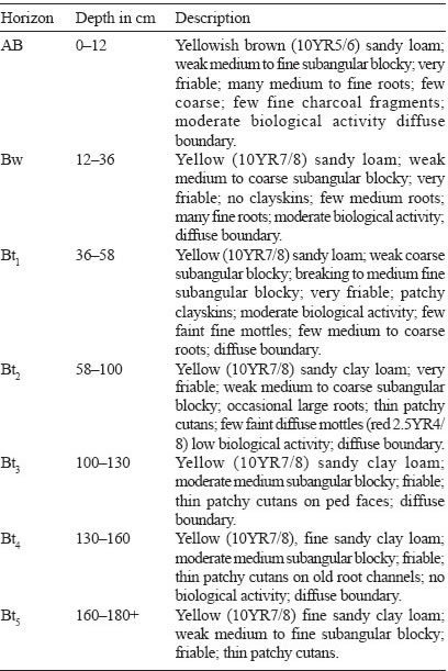
Type Location
Soils of the Bekenu Series were first described by Andriesse (1972) during the reconnaissance soil survey of West Sarawak. The above pedon was described by Lim Chin Pang for the CLAMATROPS Tour II organised by the Malaysian Society of Soil Science in 1977 at the 24th milestone Bau-Lundu Road in West Sarawak. The pedon was located on rolling (12–24% or 6–12° slopes) terrain at an elevation of 50 metres (150 feet). The vegetation was logged lowland Dipterocarp Forest. Location: Topographic Sheet 1/109/8, 1°33’20” N, 109°54’00” E (Grid Reference 1/109/8 – 892715 m).
Range in Characteristics
In the past in Sarawak, soils of the Bekenu Series were mapped as Red-Yellow Podzolic soils which can either have a cambic, kandic or argillic horizon with hues of 10YR or 2.5Y with any CECclay value. They are redefined here as soils having only an argillic horizon with red-yellow to yellow colour class and a CECclay of less than 24 cmol in all subhorizons between 25 cm to 100 cm depth. Little is known about the range in characteristics of the Bekenu Series. They generally occur on rolling, hilly to steep terrain. On the steeper terrain the profiles become moderately deep and are no longer the Bekenu Series. Textures in this soil are uniformly fine sandy clay loam and colours are brownish yellow, yellow to olive yellow (10YR6/6–6/8, 7/6–7/8, 8/6–8/8; 2.5Y6/6–6/8, 7/6–7/8, 8/6–8/8). Structure are generally weak medium to coarse subangular blocky and consistence friable. Patchy clayskins are often present. Only the deep soils are retained as belonging to the Bekenu Series in this redefinition. CECclay values are higher than 16 but less than 24 cmol (+) kg–1 clay. In some profiles a few subhorizons may have a CECclay of less than 16 cmol in the 25 to 100 cm depth.
Competing Soils and Their Differences
Soils of the Bekenu Series can easily be confused with other soils developed over mixed sedimentary rocks. Where the clay contents approach 35% they can be confused with soils of the Merit or Bedup Series in Sarawak, the Bungor Series in Peninsular Malaysia and the Kumansi/deep Series in Sabah but all of these soils have more than 35% clay while the Bekenu Series has less. Where the clay content is close to 18% soils of the Bekenu Series can be confused with soils of the Nyalau Series in Sarawak, the Malau Series in Peninsular Malaysia and Kapilit Series in Sabah all of which have less than 18% clay. Other deep soils with fine sandy clay loam textures include the Tukau Series over non-accreting alluvium and the Biawak Series with 2.5Y Hues throughout over metamorphosed sedimentary rocks in Sarawak, the Serdang Series in Peninsular Malaysia and the Tanjong Lipat Series in Sabah. In the proposed redefinition here, the Serdang Series has a kandic horizon (CECclay < 16 cmol) while the Tanjong Lipat Series has an argillic horizon with an CECclay of more than 24 cmol. The Tukau Series like soils of the Rasau Series developed over non-accreting alluvia. The Biawak Series could possibly be correlated to the Bekenu Series yellow variant and this variant could then be deleted from the list of soil series. More data is required.
Setting
Soils of the Bekenu Series typically occur on rolling and hilly terrain (slopes of 12–38% or 6–20°) at elevations of less than 1,000 metres (3,300 feet).
Principal Associated Soils
In the lowlands, soils of the Bekenu Series to-date have been mapped in association with soils of the Nyalau and Merit Series. On the steeper slopes moderately deep and shallow equivalents have also been mapped. These soils are distinguished using the particle-size class and the diagnostic horizon.
Drainage and Permeability
Soils of the Bekenu Series are well drained soils with a good permeability.
Use and Vegetation
Soils of the Bekenu Series have been used extensively for agriculture. They have been used for shifting cultivation, rubber, oil palm and pepper. On the steeper slopes these soils are retained under forest.
Distribution and Extent
To-date soils of the Bekenu Series have only been mapped in Sarawak. The actual extent of these soils is not fully known.
Series Established
This soil was first established by Andriesse (1972) during the reconnaissance soil survey of West Sarawak. The source of name is not known.
Remarks on Classification
The Bekenu Series as redefined here is classified here according to the Malaysian Soil Taxonony – Second Approximation (Paramananthan 1998) as a member of the fine loamy, siliceous, isohyperthermic, red-yellow to yellow family of Tipik Tualemkuts over sedimentary rocks. They are classified here as soils that have a deep argillic horizon with a CECclay of less than 24 cmol (+) kg–1 clay in all subhorizons between 25 to 100 cm depth and with brownish yellow colours. In the Keys to Soil Taxonomy – Eighth Edition (Soil Survey Staff 1998) these soils would probably be Typic Paleudults because these soils have a deep argillic horizon. In the FAO/UNESCO Soil Map of the World – Revised Legend (FAO 1990) the Bekenu Series would probably be classified as Haplic Acrisols due to their CECclay values of less than 24 cmol and the low base saturation.
Suitability for Agriculture
The low fertility status and the terrain on which these soils occur are the main limiting factors for the use of these soils. With proper fertilisation and soil conservation measures a wide range of crops can be cultivated on these soils. These include oil palm, rubber, pepper, fruit trees and upland rice.
Soil Profiles: Apas
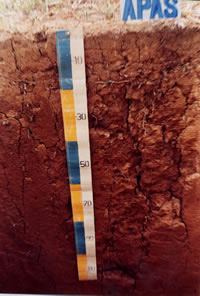
Apas Series
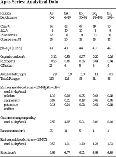
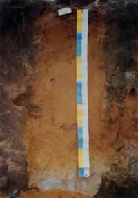
The Apas Series is a member of the Apas Family which is a very fine, oxidic, isohyperthermic, red Tipik Tempalemoks. It typifies this family and is developed over andesites. Soils of the Apas Series are characterized by their deep well drained heavy clay textured oxic horizons which have an ECEC of more than 1.5 cmol (+) kg–1 clay. These soils are red or yellowish red in colour in the subsoils. Structures are moderate to weak, fine, subangular blocky and consistence is friable.
Type Location
Soils of the Apas Series were first established by Paton (1963) during the reconnaissance soil survey of the Semporna Peninsula. The above pedon was described by Paramananthan (1997) for the Soil Familiarisation and Soil Management Tour 2/1997 Tawau-Semporna, Sabah. The pedon was located under oil palm on rolling terrain at an elevation of 150 m (450 feet) in Ladang Sungei Kawa along the Tawau-Quoin Hill road. Location: Topographic Sheet 4/118/9, 4°23’15” N, 118°01’50” E (Grid Reference 4/118/9 – 919843 m).
Range in Characteristics
Little is known about the range in characteristics of the Apas Series. The soils are almost always deep with colours ranging from yellowish red to red within 50 cm of the soil surface. Field textures are uniformly clayey with more than 60% clay. However poor dispersion sometimes gives high silt values in the analysis results. Structures are weak to moderate medium subangular blocky and consistence is friable. The ECEC must be more than 1.5 cmol (+) kg–1 clay. It must be pointed out that those soils mapped in the past as Apas Series with an ECEC of less than 1.5 cmol should be now reclassified as the Segamat Series.
Competing Soils and Their Differences
Many soils have the red colours similar to that of the Apas Series. Soils having both a red colour, heavy clay texture and an oxic horizon include soils such as the Segamat, Prang and Kampong Kalam Series. These soils have an ECEC of less than 1.5 cmol (+) kg–1 clay. Other red soils with an oxic horizon include the Tarat/deep, Sagu and Patang Series which all belong to the Apas Family. These soils have an ECEC of more than 1.5 cmol (+) kg–1 clay and are differentiated by the parent material from which they are formed. The Apas (moderately deep soil), Tarat and Jebong Series (moderately deep soil) are all developed over andesites and could possible be correlated to form just one soil series after more work is done. The Sagu Series is developed over limestone while the Patang Series over hornfels (metamorphic rocks).
Setting
Soils of the Apas Series typically occur on undulating, rolling to hilly terrain (4– 38% or 2–20° slopes) at elevation of less than 200 metres (< 660 feet).
Principal Associated Soils
The Apas Series has often been mapped together with other soils developed over fine grained intermediate and basic igneous rocks such as andesites and basalts. As redefined here soils of the Apas Series can be expected to be mapped in association with soils of the Segamat, Table Series and soils of the Kobovan and Beeston Series. In the existing maps the Apas Family included soils with an ECEC of more than and less than 1.5 cmol (+) kg–1 clay. The Apas Series as redefined here only includes soils with an ECEC of more than 1.5 cmol. Both the Kobovan and Beeston Series have an argillic/kandic horizon while the Table Series has brown colours.
Drainage and Permeability
Soils of the Apas Series are generally well to somewhat excessively drained with good permeability.
Use and Vegetation
Soils of the Apas Series have been planted with oil palm, rubber and cocoa but in some areas they remain under primary forest.
Distribution and Extent
The Apas Series has to-date been only mapped in the Sandakan and Tawau Residencies in Sabah. Their actual extent based on their redefinition here is not known but can be expected in areas mapped as Segamat in Peninsular Malaysia and as the Tarat Series in Sarawak.
Series Established
The Apas Series was established by Paton (1963) during the reconnaissance soil survey of the Semporna Peninsula. The source of name is the Apas River to the east of Tawau.
Remarks on Classification
The Apas Series as redefined here is classified according to the Malaysian Soil Taxonomy – Second Approximation (Paramananthan 1998) as a member of the very fine, oxidic, isohyperthermic, red family of Tipik Tempalemoks over fine grained intermediate and basic igneous rocks. They are classified here as soils having a deep, red oxic horizon which have heavy clay textures and an ECEC of more than 1.5 cmol (+) kg–1 clay. In the Keys to Soil Taxonomy – Eighth Edition (Soil Survey Staff 1998) this soil would probably be classified as a Typic Hapludox. In the FAO/UNESCO Soil Map of the World – Revised Legend (FAO 1990) the Apas Series would probably be classified as Haplic Ferralsols.
Suitability for Agriculture
The main limitation for agriculture in these soils is their generally low fertility status, high P fixation and their high permeability.
Soil Management: Soil Profiles
The soil profiles are taken from ‘Soils of Malaysia | Their Characteristics and Identification’ by Selliah Paramananthan from Param Agricultural Soil Surveys (M) Sdn. Bhd., A4-3 Jalan 17/13, Happy Mansion Block A, Section 17, 46400 Petaling Jaya, Selangor, Malaysia. To purchase this book, please click here.
Please select soil name:
Problem Soils: Conclusions
[addw2p name=”problemSoils”]
Proper understanding of soils and crops has allowed us to exploit marginal soils successfully in Malaysia. Upon corrections or alleviation of the soil constraints, the oil palm performances can generally match those on better soil types. More than one soil management approaches are usually required and these must be implemented correctly and interactively. Among others, good timing is also essential to ensure success.
It must be cautioned that cultivation of oil palms on marginal soils entails higher cost, difficult inputs, good managerial skill and exposes the planters to higher risk and poorer competitiveness. It is therefore advisable to regard planting on marginal soils as a last resort rather than an opportunity for development and business.
Problem Soils: Managing Sandy Soils (Quartzipsamments)
[addw2p name=”problemSoils”]
Lintang
The extent of quartzipsomments in Malaysia has not been reported. However, they are known to occur extensively besides mining or ex-mining areas and flat river basins. Some of these soils are classified as Sg. Buloh, Subang, Nangka, Lintang and Jambu series. The major limitations of these soils mirror those of podzols except that perched water table does not exist.
The management procedures for oil palms on these sandy soils are similar to those on podzols except that scupper drains are not dugged. Our experience with plantings on these soils has been fortunate because they occur in high rainfall regions of Central Perak and Southern Kedah. Their yield performances are shown in Figure 7 also.