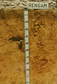
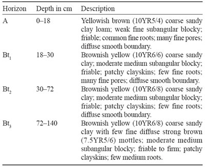
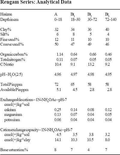
Soil Profiles: Rengam
Rengam Series
The Rengam Series is a member of the Rengam Family which is a fine, kaolinitic, isohyperthermic, red-yellow Tipik Lutualemkuts. It typifies this family which is developed over coarse grained acid igneous rocks. The soils have a thin brown coarse sandy clay loam A horizons and deep uniform brownish yellow to yellowish brown coarse sandy clay to clay B horizons. The soils have moderately developed medium subangular blocky structures and friable consistence which gets firmer with depth. The soils occur on undulating, rolling and hilly terrain. They are derived from granitic parent material. Chemically these soils have a CECclay of less than 16 cmol (+) kg–1 clay in all subhorizons between 25 to 100 cm depth.
Type Location
The soils of the Rengam Series were first established in the Simpang Rengam area of Johore possibly by Owen or Jansen. The soil was subsequently described by Panton during the Reconnaissance Soil Survey of Terengganu. The above pedon was described in the Agricultural Museum, near Kuantan, Pahang on rolling terrain (16% slope) at an elevation of 50 m (150 feet). Location: Topographic Sheet 4360, 3°48′ N, 103°20′ E (Grid Reference 4360 – 930210 m).
Range in Characteristics
The A horizon of the Rengam Series is often a brown to dark brown (10YR4/ 3, 5/3) coarse sandy clay to coarse sandy clay loam. The B horizon are often uniform and deep. The colours in the B horizons are uniformly brownish yellow to yellowish brown (10YR6/8, 6/6, 5/6, 5/8), and strong brown (7.5YR5/6, 5/8). The textures in the B horizons range from coarse sandy clay through sandy clay to clay. The clay percentage ranges from 30 to 55% and seldom exceeds 60%. Invariably coarse sand dominates the sand fraction by a ratio of more than 3:1. The Rengam Series as mapped in the past had much wider range in properties and a coarse sandy type (actually gravelly type), a red variant and a clay type were also mapped. These are however now excluded from the Rengam Series. The Rengam Series as redefined here cannot have hues of 5YR or redder within the upper 50 cm (Rengam/red variant). The amount of gravels in the upper 50 cm cannot exceed 35% (Beserah Series). The dominance of the coarse sand (often as high as 30–40%) makes the field texture sometimes difficult to assess. Structures in the B horizons are moderate to weak medium subangular blocky and consistence friable. Clayskins are developed but they are often best developed at depths below 50 cm. The profiles are often very deep and exceed 3–4 m before the weathered rock is encountered. With depth the colours become redder and gravel content gradually increases.
Competing Soils and Their Differences
The Rengam Series as mapped in the past had a fairly wide range. It is therefore redefined here to only include soils derived from granitic parent materials and which have the upper part of the B horizons having brownish yellow or yellowish brown or strong brown colours and coarse sandy clay to clay textures. They have a clay distribution which does not decrease significantly with depth (to 1.0 m) and have a kandic horizon (CECclay less than 16 cmol (+) kg–1 clay in all horizons within the 25 to 100 cm depth. The Rengam Series as redefined here is commonly associated with soils such as the Beserah and Baling Series. The Rengam Series is also often associated with soils of the Tampin Series. The Beserah Series has many features similar to that of Rengam Series but has a gravelly clay texture within 50 cm – gravel content exceeds 35%. The Bukit Temiang Series is easily differentiated from the Rengam Series by the appearance of the weathered parent material within one metre of the soil surface. The Baling Series also has a clay distribution which often decreases with depth. The Lambak and Bukit Temiang Series are differentiated from the Rengam Series by their redder hues (5YR and 2.5YR) which appear within 50 cm of the soil surface. The Tampin Series on the other hand has much paler colours – yellow to olive colours in the upper part of the B horizon. The Rengam Series is also often associated with soils of the Jerangau Series. They are however easily distinguished from the Jerangau by the coarse sand of the Rengam Series. The Harimau Series formed on colluvial wash and Older Alluvium derived from granites is very similar to the Rengam but it (Harimau) has shallower profiles with rounded gravels often encountered at depths below 100 cm. The coarse sand in the Harimau Series is also less angular and has a clouded appearance. The Rengam has a coarse sand-fine sand ratio of about 3:1 or greater while the Harimau 1.5:1. The Harimau Series also has much weaker structures and generally the colours become paler with depth. Other soils derived from sandstones and quartz mica schists such as Serdang, Bungor and Batang Merbau have colours similar to the Rengam Series but lack the typical angular quartz in the coarse sand fraction. These soils also have a higher proportion of fine sand. No granitic derived soils with similar features to the Rengam Series have been mapped to-date in Sabah. In Sarawak, the Abok and Gumbang Series over acid igneous rocks have a fine loamy particle-size class.
Setting
The Rengam Series as redefined here occurs on slopes ranging from gently undulating through rolling to hilly and steep. They are more common on the undulating and hilly terrain while the Baling and Bukit Temiang Series are common on hilly to steep terrain. The Rengam Series occur on elevations ranging from 50–200 metres (150–650 feet).
Principal Associated Soils
The Rengam Series as defined here is commonly associated with soils of the Lambak, Beserah and Bukit Temiang and Baling Series. The Rengam Series soils are however distinguished from these by the lower gravel content in the profile. These soils have gravelly clay textures or are shallower profiles. The Bukit Temiang and Lambak Series also have redder hues within 50 cm of the surface. The Jerangau Series has a strong brown colours and clayey textures and lacks the angular quartz. The Lanchang Series has more than 60% clay.
Drainage and Permeability
Soils of the Rengam Series are well drained and the permeability is good.
Use and Vegetation
The Rengam Series has been planted with a wide range of crops. Rubber, oil palm, fruit trees, pines (pinus) and cash crops on the gentler slopes. Some of the areas are also currently under primary forest. By far the commonest crops are rubber and oil palm.
Distribution and Extent
The Rengam Series is probably the most widespread soil in Peninsular Malaysia. They occur in all states of the Peninsular except Perlis. To-date no soils similar to the Rengam Series have been mapped in Sabah or Sarawak.
Series Established
The Rengam Series was probably first established near the village of Simpang Rengam near Keluang in Johore. The source of name is Simpang Rengam Village, Johore, Peninsular Malaysia.
Remarks on Classification
The Rengam Series is classified here according to the Malaysian Soil Taxonomy – Second Approximation (Paramananthan 1998) as a member of the fine kaolinitic isohyperthermic red-yellow family of the Tipik Lutualemkuts. They are classified as soils having a deep kandic horizon which extends to a depth of 1.0 m without any significant decrease in clay with depth and with 35 to 60% clay and strong brown to brownish yellow colours. In the Keys to Soil Taxonomy – Eighth Edition (Soil Survey Staff 1998) the Rengam Series soils would be classified as Typic Kandiudults. In the FAO/ UNESCO Soil Map of the World – Revised Legend (FAO 1990) the Rengam Series would be classified as Haplic Nitisols.
Suitability for Agriculture
The soils of the Rengam Series are suitable for a wide range of crops. Terrain is the only limiting factor for this soil and the soil is prone to erosion on the steeper slopes. As such good soil conservation practices must be practiced on rolling, hilly and steep terrain. A proper fertilizer program is however essential in order to obtain good yields. The soils of the Rengam Series are suitable for a wide range of crops. Terrain is
Soil Profiles: Prang

Prang Series
The Prang Series is a member of the Segamat Family which is a very fine, oxidic, isohyperthermic, red Tipik Akrolemoks. It is developed over amphibolite and schist parent materials. These are deep (> 100 cm) uniformly red coloured soils. These soils are characterized by thin clayey A horizons with dark reddish brown colours and B horizons having yellowish red to red colours, heavy clay textures with very weak, medium to fine subangular blocky structures and very friable consistence. These soils are often very deep but hard petroplinthite concretions may occur as a loose band at depths below 100 cm.

Type Location
Soils of the Prang Series were first established in Prang Besar Estate, near Kuala Lumpur during the Reconnaissance Soil Survey of Selangor (Wong 1966). The above pedon was described from the same estate at the midslope of a rolling hill (16–20% or 8–10°) slope at an elevation of about 70 metres (200 ft) above sea level. Location: Topographic Sheet 3756, 2°55′ N, 101°42′ E (Grid Reference 3756 – 120230 m)
Range in Characteristics
The A horizons of the Prang Series range in colour from dark reddish brown to reddish brown (5YR3/3, 3/4, 4/3; 2.5YR2.3/4) with clay loam to clay textures. The B horizons range in colour from red to yellowish red (2.5YR4/6, 4/8, 5/6, 5/8; 5YR4/6, 5/6, 5/8). Textures are uniformly clayey with clay contents often over 65% but in the mechanical analyses lower clay contents are obtained due to poor dispersion. Structures are weak to very weak medium to fine subangular blocky and consistence very friable. Clayballs are sometimes found in the B horizons. Horizonation is weak and the profiles are often deep. Occasionally particularly at the crest of the hills petroplinthite nodules or iron coated schist material may be present but embedded in the clayey B matrix. This laterite band often occurs at depths of about one metre or greater. Sometimes a thin loose band of pisiform petroplinthite nodules may also occur within one metre but these are then thin bands.
Competing Soils and Their Differences
The Prang Series because of its typical reddish colours is easily mistaken for the Segamat, Patang, Kampong Kolam, Tarat and Apas Series. In fact unless the parent material is known it is virtually impossible to separate these soils. The Prang Series often has somewhat slightly more sand compared to the Segamat Series but as mentioned earlier poor dispersion may even make such differentiation impossible. The Patang Series mapped in Terengganu and Johore is also very similar to the Prang Series. The Patang Series is reported to be slightly firmer with depth and often has outcrops of hornfels at the surface. The Patang Series has a CECclay of more than 1.5 cmol. The Tarat Series and Apas Series are developed over andesites or basalts and have cation retention capacity over 1.5 cmol (+) kg–1 clay.
Setting
The soils of the Prang Series typically occur on undulating to rolling terrain. They have to-date been mapped at elevations of 0–100 metres (0–300 ft). These soils often occur on the lower slopes of hills which have the Malacca or Seremban Series on their crests.
Principal Associated Soils
The Prang Series have often been mapped in association with soils of the Munchong Series, Chat Series, Seremban Series and Malacca Series. Sometimes they have also been mapped in association with soils of the Serdang Series. The Munchong Series is separated from the Prang Series by its yellower hues. The Munchong Series has hues of 7.5YR and 10YR in the upper part (50 cm) of the B horizon. The Chat Series has colours similar to that of the Munchong Series and has an argillic horizon. The Seremban Series also has red colours but is characterized by the presence of platy iron-coated schist fragments within 50 cm. The Malacca Series is characterized by the presence of a thick band of angular petroplinthite gravels which occur within 50 cm of the surface.
Drainage and Permeability
Drainage in the Prang Series is somewhat excessive. Permeability is good. These soils because of the aggregation of the clay are very porous.
Use and Vegetation
The Prang Series has been mainly planted with rubber, fruit trees and oil palm. In some areas these soils are still under primary forest vegetation.
Distribution and Extent
The Prang Series as defined here has been mapped in around Kajang in Selangor, near Tanjong Malim in Perak, around Sg. Tebak in Terengganu and near Bekok in Johore and in isolated pockets in Malacca and Pahang. Recently it has also been found in Kedah. The actual extent of these soils is not fully known as they have often been mapped in association with other soils.
Series Established
This soil was established in Prang Besar Estate, near Kuala Lumpur. The source of name is Prang Besar Estate, Selangor, Peninsular Malaysia. This area has now been cleared for urban development.
Remarks on Classification
The Prang Series is classified here according to the Malaysian Soil Taxonomy – Second Approximation (Paramananthan 1998) as a member of the very fine, oxidic, isohyperthermic, red family of Tipik Akrolemoks which is developed over amphibolites and schists. They are classified here as soils having a deep oxic horizon, heavy clay textures, weak structures and a low (< 1.5 cmol (+) kg–1) clay cation retention capacity in the B horizon. In the Keys to Soil Taxonomy – Eighth Edition (Soil Survey Staff 1998) the Prang Series would probably be classified as Typic Hapludox. In the FAO/ UNESCO Soil Map of the World – Revised Legend (FAO 1990) the Prang Series would probably be classified as Geric Ferralsols.
Suitability for Agriculture
Soils of the Prang Series have a somewhat excessive drainage. Thus moisture availability particularly the establishment of the crop can be difficult. These soils also have low nutrient content and can fix large amounts of phosphorus. These soils have however been classified as Class 1 soils for rubber. In the case of oil palm and cocoa the rainfall distribution pattern of the area where the Prang Series occurs will determine its suitability rating.

Soil Profiles: Nyalau

Nyalau Series
The Nyalau Series is a member of the family of coarse loamy, siliceous, isohyperthermic, red-yellow to yellow Tipik Tualemkuts. It is developed over sedimentary rocks in which sandstones dominate. Soils of the Nyalau Series are characterized by their deep, well drained profiles with fine sandy loam textures. Colours range from brownish yellow to yellow. Structures are weak medium to fine subangular blocky and consistence is friable to 100 cm but gets firmer with depth. There is some problem in determining the diagnostic horizon. Mostly it is agreed that this soil has an argillic horizon but some believe that this soil has a cambic horizon. In this description here the soil is assumed to have an argillic horizon. These soils have a CECclay of less than 24 cmol (+) kg–1 soil in all subhorizons between 25 to 100 cm depth.

Type Location
Soils of the Nyalau Series were first described by Andriesse (1972) during the Reconnaissance Soil Survey of West Sarawak. The above pedon was described by Lim Chin Peng for the CLAMATROPS Tour II organised by the Malaysian Society of Soil Science in 1977 at the 24th milestone Bau-Lundu Road in West Sarawak. The pedon was located close to the crest of a 15° (30%) hill at an elevation of 110 m (³ 350 feet). The vegetation was a poor stand of Lowland Dipterocarp Forest merging into a ‘Kerangas’ forest. Location: Topographic Sheet 1/109/8, 1°33′ N, 109°54’30” E (Grif Reference 1/109/8 – 897705 m).
Range in Characteristics
Little is known about the range in characteristics of the Nyalau Series. They generally occur on rolling, hilly to steep terrain over sandstones and quartzites. Most of the soils described to-date are deep. Field textures are fine sandy loams and colours range from brownish yellow to yellow (10YR6/6–6/8 to 10YR7/6– 7/8, 8/6–8/8, 2.5Y7/6–7/8, 8/6–8/8). Structures are weak fine and medium subangular blocky and consistence is friable. Occasionally some organic coatings are present on ped faces. The cation exchange capacity values on the soil are low often less than 5 cmol (+) kg–1 soil. Base saturation values are very low. Soils of the Nyalau Series are redefined here as soils having a CECclay of less than 24 cmol (+) kg–1 clay in all subhorizons between 25 to 100 cm depth but has at least one subhorizon with a CECclay of > 16 cmol.
Competing Soils and Their Differences
Soils of the Nyalau Series are easily confused for other soils developed over sandstone material such as the Bekenu Series in Sawarak, the Malau and Serdang Series in Peninsular Malaysia and the Tanjong Lipat, Kapilit, Antulai and Laab Series in Sabah. The Bekenu, Serdang and Laab Series all have fine sandy clay loam textures while the Nyalau Series has fine sandy loam textures. The Antulai Series is often a moderately deep (50–100 cm) soil while the Nyalau Series is deep (> 100 cm). Both the Kapilit and Malau Series are reported to have clayskins. Differences in colour and CECclay values can be used to separate these soils. Both the Kapilit and Malau Series have a CECclay value of more than 24 cmol in at least some subhorizon between 25 to 100 cm depth.
Setting
Soils of the Nyalau Series typically occur on rolling, hilly to steep terrain (slopes in excess of 24% or 12°) at elevations in excess of 50 m (150 feet).
Principal Associated Soils
Soils of the Nyalau Series being developed over sandstones are commonly associated with soils of the Bekenu, Kapilit and Malau Series. As mentioned earlier these soils are separated using the clay content and their CECclay values.
Drainage and Permeability
Soils of the Nyalau Series are well drained. Permeability is good.
Use and Vegetation
Due to their sandy loam textures, the slopes on which they occur and their low fertility status, areas with the Nyalau Series are mostly under poor forests. Some areas however have been used for shifting cultivation, rubber, pepper, oil palm and fruit trees.
Distribution and Extent
To-date soils of the Nyalau Series have only been mapped in Sarawak. Their actual extent is not known.
Series Established
This soil was established by Andriesse (1972) during the reconnaissance soil survey of West Sarawak. The source of name is not known.
Remarks on Classification
The Nyalau Series is classified here according to the Malaysian Soil Taxonomy – Second Approximation (Paramananthan 1998) as a member of the coarse-loamy, siliceous, isohyperthermic, red-yellow to yellow family of Tipik Tualemkuts over sedimentary rocks. They are classified here as soils having a deep well drained argillic horizon with a low base saturation and a CECclay of 16 to 24 cmol (+) kg–1 clay. In the Keys to Soil Taxonomy – Eighth Edition (Soil Survey Staff 1998) this soil would probably be classified as Typic Paleudults since the soil has an argillic horizon, an udic moisture regime and a low base saturation. In the FAO/UNESCO Soil Map of the World – Revised Legend (FAO 1990) the Nyalau Series would probably be classified as Haplic Acrisols due to its argic horizon and low base saturation values.
Suitability for Agriculture
Due to their sandy loam textures, low fertility status, low water holding capacity and high erodibility soils of the Nyalau Series are best left under natural vegetation.

Soil Profiles: Nobusu

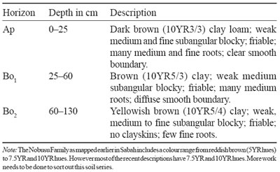
Nobusu Series
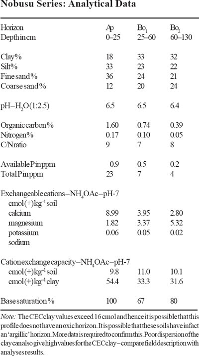
The Nobusu Series is a member of the Nobusu Family which is a fine, oxidic, isohyperthermic brown Tipik Tempalemoks. It typifies this family and is developed over alluvium and outwash from basic and ultrabasic rocks. Soils of the Nobusu Series are characterized by their deep, moderately well to well drained oxic horizon with a clay content of 35–60%, a colour which is brown to yellowish brown and an ECEC of more than 1.5 cmol (+) kg–1 clay. Structures are weak medium subangular blocky and consistence is friable
Type Location
Soils of the Nobusu Series were first established during the reconnaissance soil survey of Sabah (Acres et al. 1975) as the Nobusu Family. The above pedon was described by Paramananthan (1996) in Meliau Estate, near Telupid, Sabah. The above pedon was located on gently undulating terrain (4–12% or 2–6° slopes) at an elevation of around 16 m (50 feet) a.s.l. under oil palm. Location: Topographic Sheet 5/117/1, 5°47’20” N, 117°11’45” E (Grid Reference 5/117/ 1 – 987396 m).
Range in Characteristics
Little is known about the range in characteristics of the Nobusu Series. As mentioned earlier the Nobusu Family as mapped earlier had reddish brown to brown colours and also a clay content that ranges from 35 to 75%. The Nobusu Series as redefined here must have an oxic horizon with a hue of 7.5YR or yellower and a value/chroma of 5/3, 5/4, 4/3, 4/4, 3/3, 3/4 at 50 cm depth. The clay contents in the oxic horizon should be between 35% to 60%. Drainage is moderately well to well drained. Structures are weak medium to fine subangular blocky and consistence is friable. The ECEC values must be more than 1.5 cmol (+) kg–1 clay.
Competing Soils and Their Differences
As very few Oxisols are developed over alluvium these soils are not likely to be confused with many other soils. The presence of a brown coloured oxic B horizon can confuse the Nobusu Series with the Kuantan Series and Table Series over basalt. The Kuantan Series occurs on undulating to rolling terrain and has a ECEC of less than 1.5 cmol (+) kg–1 clay. The Table Series has brown colours and the same ECEC (> 1.5 cmol) as the Nobusu Series, but is a heavy clay (> 60% clay) textured soil. The Ambun Series over serpentinite has similar textures but is reddish brown in colour. Some soils such as the Besar Series can have similar colours but have an argillic horizon.
Setting
The soils of the Nobusu Series typically occur on level to undulating terrain (alluvial terraces, colluvial deposits) adjacent to steephills of basic or ultrabasic rocks. Terrain is level to undulating (0–12% or 0–6° slopes) at elevations of up to 200 m (600 feet).
Principal Associated Soils
Soils of the Nobusu Series being developed over alluvium from basic and ultrabasic rocks are associated with soils of the Pinianakan Series, Ambun Series and Table Series. These soils typically occur on rolling to steep terrain, have heavier textures or reddish brown colours.
Drainage and Permeability
Soils of the Nobusu Series are moderately well to well drained. Permeability is moderate to good.
Use and Vegetation
In the Telupid area where such soils have been mapped the Nobusu Series is mainly under primary forest. Some small areas have recently been planted with oil palm.
Distribution and Extent
The Nobusu Series has to-date been only mapped in Sabah mainly in the Telupid area. Their actual extent is not known.
Series Established
This soil was established during the reconnaissance soil survey of Sabah (Acres et al. 1975). The source of name is not known.
Remarks on Classification
The Nobusu Series is classified here according to the Malaysian Soil Taxonomy – Second Approximation (Paramananthan 1998) as a member of the fine, oxidic, isohyperthermic, brown family of Tipik Tempalemoks over alluvium from basic and ultrabasic igneous rocks. They are classified here as soils having a deep oxic horizon with a clay content of 35–60%, yellowish brown to brown colours and a ECEC of more than 1.5 cmol (+) kg–1 clay. In the Keys to Soil Taxonomy – Eighth Edition (Soil Survey Staff 1998) these soils would probably be classified as Typic Hapludox. In the FAO/ UNESCO Soil Map of the World – Revised Legend (FAO 1990) the Nobusu Series would probably be classified as Haplic Ferralsols.
Suitability for Agriculture
The main limitation for agriculture for these soils is their generally low fertility status. With proper fertilization these soils are capable of supporting a wide range of crops.
Soil Profiles: Munchong

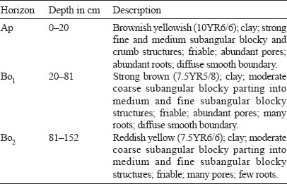
Munchong Series
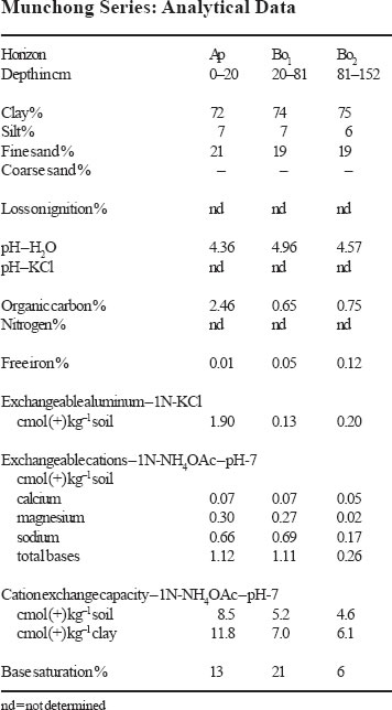
The Munchong Series is a member of the Munchong Family which is a very fine, kaolinitic, isohyperthermic, red-yellow Tipik Tempalemoks. It typifies this family and is developed over fine grained sedimentary rocks (shale) and low grade metamorphic rocks. Soils of the Munchong Series are characterized by their deep heavy clay textured oxic horizons which have yellowish brown to strong brown colours and an ECEC in the 25 to 100 cm of more than 1.5 cmol (+) kg–1 clay. Soil structures are weak medium to fine subangular blocky and consistence is friable.
Type Location
Soils of the Munchong Series were probably first established by Owen (1951) on Munchong Estate near the village of Kuala Kubu Baharu in Selangor. The above pedon was described by Chan (1975) as part of his M.Sc. study. The soil was located on Field 54 RRIM Experiment Station in Sungei Buloh, Selangor on flat to gently undulating terrain (0–12% or 0–6° slopes) at an elevation of 15– 30 metres a.s.l. Location: Topographic Sheet 3757, 3°11′ N, 101°34′ E (Grid Reference 3757 – 965525 m).
Range in Characteristics
Soils of the Munchong Series must have a clay content of over 60% and colours that range from brownish yellow and yellowish brown (10YR5/6–5/8, 6/6–6/8) to strong brown (7.5YR5/6–5/8) at 50 cm depth. These are soils with a deep oxic horizon extending to over 125 cm. Occasional a thin band of fine petroplinthite gravels may be present. Structures are weak medium to fine subangular blocky and consistence is friable. Chemically these soils have an ECEC of more than 1.5 cmol (+) kg–1 clay.
Competing Soils and Their Differences
Soils of the Munchong Series because they have heavy clay textures and yellowish brown to strong brown colour with an oxic horizon can be confused with soils having similar textures and colours such as the Jerangau, Senai, Jarangan, Katong and Tangga Series with an oxic horizon and soils such as the Lanchang and Chat Series with a kandic horizon. Soils of the Jerangau and Senai Series are developed over granodiorite and gabbro parent material respectively and have an ECEC of less than 1.5 cmol (+) kg–1 clay. The Jarangan, Katong and Tangga Series are similar to the Munchong Series but are developed over basalts, andesites and limestone respectively. Both the Lanchang and Chat Series have a kandic horizon.
Setting
Soils of the Munchong Series typically occur on undulating, rolling, to hilly terrain (4–38% or 2–20° slopes) at elevations of less than 200 m (600 feet).
Principal Associated Soils
Soils of the Munchong Series have to-date been only mapped in Peninsular Malaysia. They have been mapped in many parts of Peninsular Malaysia where they occur in association with soils of the Malacca and Gajah Mati Series in a catena relationship with the petroplinthic soils of the Malacca and Gajah Mati occupying the crest of hills. Soils of the Munchong Series have also been mapped in association with the redder coloured soils of the Prang Series. During the reconnaissance soil surveys many areas have been mapped as associations of the Munchong Series with soils of the Serdang, Bungor and Durian Series.
Drainage and Permeability
Soils of the Munchong Series are generally well to somewhat excessively drained and have a rapid permeability.
Use and Vegetation
Soils of the Munchong Series have been extensively cultivated to oil palm, rubber and fruit trees. On the gentler slopes cash crops have also been planted.
Distribution and Extent
Soils of the Munchong Series have been mapped quite extensively in many States of Peninsular Malaysia from Kedah to Johor. Their total extent is however not known.
Series Established
This soil was established by Owen (1951) during the mapping of rubber growing areas in Peninsular Malaysia. The source of name is Munchong Estate near Kuala Kubu Baharu in Selangor.
Remarks on Classification
The Munchong Series is classified here according to the Malaysian Soil Taxonomy – Second Approximation (Paramananthan 1998) as a member of the very fine, kaolinitic, isohyperthermic red-yellow family of Tipik Tempalemoks. They are classified here as soils with a deep well drained oxic horizon which have yellowish brown to strong brown colours and an ECEC of more than 1.5 cmol (+) kg–1 clay. In the Keys to Soil Taxonomy – Eighth Edition (Soil Survey Staff 1998) the Munchong Series would probably be classified as Haplic Hapludox. In the FAO/UNESCO Soil Map of the World – Revised Legend (FAO 1990), the Munchong Series would probably be classified as Haplic Ferralsols.
Suitability for Agriculture
The main limitations for the use of the Munchong Series for agriculture would be their low fertility status and the slope on which these soils occur. The Munchong Series soils should be suitable for wide range of crops.
Soil Profiles: Miri
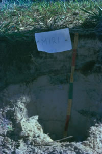
Miri Series
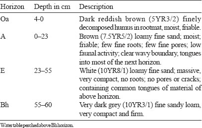
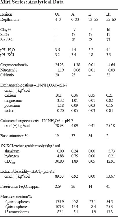
The Miri Series is a member of the Miri Family which is a sandy, isohyperthermic, strongly cemented Tipik (Jelik) Tempahumits. It typifies this family and is developed over non-accreting Pleistocene terraces. Soils of the Miri Series are characterized by the presence of an albic horizon and a thick spodic horizon. The spodic horizon which has its upper boundary between 50 to 100 cm of the soil surface is strongly cemented and has a chroma of less than 3 in more than 50% of its thickness. Often due to the cemented spodic horizon a perched water table occurs above it making the soil imperfectly to well drained depending on the depth at which the cemented spodic is encountered.
Type Location
Soils of the Miri Series were probably first established in Sarawak by Andriesse (1972). The above pedon was described by Lim Chin Pang for the CLAMATROPS TOUR II organised by the Malaysian Society of Soil Science in 1977. The pedon was located on a level terrain over High Level Pleistocene Alluvium at the end of the north Pan Road, near the Old Kuching Airport at an elevation of 20 metres (60 feet). The vegetation consists of old secondary pole-like trees. Location: Topographic Sheet 1/110/10, 1°28’50” N, 110°20’00” E (Grid Reference 1/110/10 – 368634 m).
Range in Characteristics
Little is known about the range in characteristics of the Miri Series. As redefined here soils of the Miri Series should only be developed over Older Alluvial terraces. The soil must have a spodic horizon which has its upper boundary between 50 to 100 cm of the mineral soil surface. The spodic horizon must be strongly cemented and have a chroma of 3 or less indicating that it is humus-rich. Due to the strongly cemented spodic horizon the soil has a perched water table below 50 cm making it somewhat imperfectly to well drained. This however depends on the depth at which the spodic is encountered and the time of the year the soil is described.
Competing Soils and Their Differences
The Miri Series, having a spodic horizon, is only likely to be confused with other soils with a spodic horizon. As defined here, the Miri Series is developed over Old Alluvium or Non-accreting alluvium and not over residuum or over beach ridges. They thus occur at elevations above 16 m (50 feet) on gently undulating to level terraces. Often at depth, rounded pebbles may be encountered. Secondly soils of the Miri Series have a strongly cemented spodic horizon which has a chroma – 3 in more than 50% of the spodic and the top of the spodic horizon is encountered between 50 to 100 cm depth. Only two other soils with a spodic horizon at 50 to 100 cm occur over non-accreting alluvium. The Karamatoi Series is similar to the Miri Series but has a spodic horizon that is weakly or non-cemented. The Silimpopon series which has a spodic horizon at 50 to 100 cm which is strongly cemented but the spodic horizon has a colour that has a chroma of greater than 3 i.e. iron-rich. Soils of the Rudua Series (strongly cemented) occur over beach ridges while soils of the Bako Series occur over sedimentary rocks.
Setting
Soils of the Miri Series typically occur on undulating to level terrain (slopes of 0–12% or 0–6°) on Older Alluvium or Raised Terraces at elevations of more than 16 m (50 feet) but often less than 50 m (150 feet).
Principal Associated Soils
Soils of the Miri Series are commonly associated with soils of the Karamatoi Series (weakly cemented spodic) and the Buso Series (spodic < 50 cm and weakly cemented). All these soils have a humus rich spodic horizon. Where iron contents increase they may be associated with soils of the Silimpopon series (iron-rich, cemented spodic).
Drainage and Permeability
Drainage to the top of the spodic horizon is good to excessive. The cemented spodic results in a perched water table above it. Permeability to the spodic horizon is good. Water can stagnate during the rainy seasons but the soil can be dry in the dry season.
Use and Vegetation
Due to the sandy textures and drainage problems (excessive to poor) most of the areas have a very poor kerangas forest or secondary vegetation. Many areas have been burnt during the dry season leaving only secondary growth and imperata species.
Distribution and Extent
To-date soils of the Miri Series have only been mapped in Sarawak but they are also expected to be present in Sabah.
Series Established
Originally the Miri Series was defined over beach ridges and then extended to cover soils with a spodic horizon on terraces. As defined here they are now only confined to raised terraces. The series was established by Andriesse (1972). The source of name is Miri town in Sarawak.
Remarks on Classification
The Miri Series is classified here according to the Malaysian Soil Taxonomy – Second Approximation (Paramananthan 1998) as a member of the sandy, siliceous, strongly cemented, isohyperthermic family of Tipik (Jelik) Tempahumits developed over old terraces. They are classified here as soils having a humus rich cemented spodic horizon (chroma – 3) at a depth of between 50 to 100 cm. These soils are developed over old terraces but not over beach ridges. Drainage in these soils is imperfect to well drained. In the Keys to Soil Taxonomy – Eighth Edition (Soil Survey Staff 1998), soils of the Miri Series are probably classified as an Oxyaquic Haplorthods because the spodic horizon has less than 6% organic carbon and the soil has a perched water table around 60 cm. In the FAO/UNESCO Soil Map of World – Revised Legend (FAO 1990) soils of the Miri Series are probably Haplic Podzols.
Suitability for Agriculture
Due to their sandy textures and very poor fertility status, soils of the Miri Series are not suitable for agriculture and are best left under their natural vegetation. However care must be taken to prevent fires during the dry season.
Soil Profiles: Marang
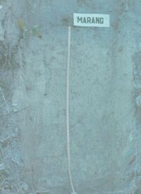
Marang Series
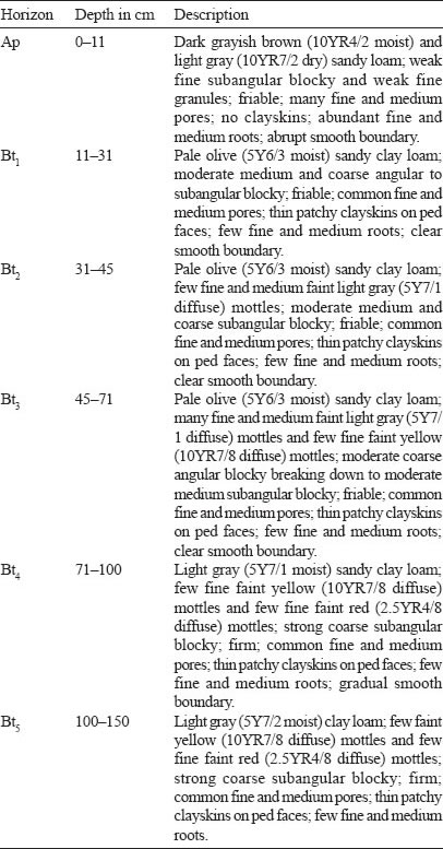
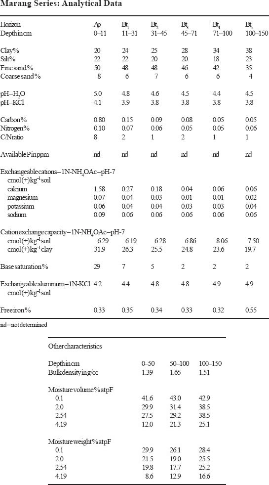
The Marang Series is a member of the family of fine loamy, siliceous, isohyperthermic, yellow Allik Tualemkuts. These soils are developed over iron-poor sandy indurated shales. They are characterized by fine sandy clay loam subsoils with pale olive or pale yellow colours with weak to medium subangular blocky structures and friable to firm consistence. Patchy clayskins occur on ped faces. The soil colour changes to light gray below 50 cm depth where red mottles are also common. These pale coloured horizons show distinct mottling. Sometimes a thin band of vein quartz fragments occurs between the upper and lower parts of the profile. Most of these soils are deep although some moderately deep soils have also been encountered. These soils commonly occur on rolling to hilly terrain. Chemically these soils have a CECclay of more than 24 cmol in some subhorizon between 25 to 100 cm of the soil surface.
Type Location
The Marang Series was first established by Panton (1958) during the Reconnaissance Soil Survey of Terengganu near Marang town. The above pedon was described by K.F. Loh and Paramananthan and studied in detail by Loh (1981) at the Bukit Goh Oil Palm Scheme near Kuantan on the midslope of low undulating to rolling hills. Location: Topographic Sheet 4360, 3°55′ N, 103°15’15” E (Grid Reference 4360 – 850330 m).
Range in Characteristics
Very little is known about the range in characteristics of the Marang Series. The textures in the subsoil are uniformly fine sandy clay loam with clay contents gradually increasing with depth to over 100 cm. The colours in the upper part of the B to just below 50 cm has hues of 10YR, 2.5Y or 5Y but often have chromas of three or four. The values are often moderate to high (> 5) resulting in colours ranging from very pale brown, pale brown, light yellowish brown; pale yellow and pale olive (10YR6/3, 6/4, 7/3, 7/4, 8/3, 8/4; 2.5Y6/4, 7/4, 8/4; 5Y6/3, 6/4, 7/3, 7/4, 8/3, 8/4). At depths below 50 cm and below the vein quartz stoneline the colour becomes paler – light gray to white. Often a layer of vein quartz occurs between these two layers. Few red mottles occur in these lower horizons. Structures are weak to moderate medium and fine subangular blocky and consistence friable to firm. Patchy clayskins are common on ped faces. Drainage in these soils is moderately well to somewhat imperfect. After rain, water may stand on the surface. The depth at which the weathered shale saprolite occurs varies from around 60 cm to just over one metre. Soils of the Marang Series occur over a wide range on terrain classes ranging from undulating, rolling to hilly.
Competing Soils and Their Differences
Soils of the Marang Series may be mistaken for other soils which have similar pale colours such as the Batu Anam Series, Apek Series, Chenian Series and Pohoi Series. The Pohoi Series, Chenian Series and Durian Series are all heavier textured and stronger coloured. The Batu Anam Series is paler coloured and also heavier textured. The Apek Series which often occurs together with the Marang Series has similar fine sandy clay loam textures but the colours of the Apek Series are paler with chromas of 2 or less while the Marang Series has chromas of 3 and 4. No soils in Sabah with a deep argillic horizon with pale yellow colours and fine sandy loam textures have been identified to-date. In Sarawak, some soils mapped as the Durin Series (Grey-White Podzolics) could possibly be correlated with soils of the Marang Series. More data is required before this can be done.
Setting
Soils of the Marang Series have been mapped mainly over undulating to rolling terrain. Occasionally they have also been mapped on hilly to steep terrain.
Principal Associated Soils
The Marang Series has to-date been mapped in association with the Apek and Kuala Brang Series. The Apek Series has pale colours with chromas of 2 or less while the Kuala Brang has chromas of 6 or 8. The Kuala Brang Series is also heavier textured.
Drainage and Permeability
Soils of the Marang Series are moderately well to imperfectly drained. The permeability in the upper 50 cm is moderate to high but this becomes slow to moderate at depth.
Use and Vegetation
Rubber is by far the commonest crop grown on this soil to-date although oil palm has also recently been planted. Some of the areas with this soil are still under forest while others are under fruit trees or secondary forest.
Distribution and Extent
The main extent of the Marang Series is on the East Coast. These soils are extensive in Terengganu around the town of Marang and Kampong Buloh. They have also been mapped in the Bukit Goh and Rompin Plateau areas of Pahang and in eastern part of Negeri Sembilan and Johor.
Series Established
This soil was established near the town of Marang, Terengganu. The source of name is the town of Marang, Terengganu, Peninsular Malaysia.
Remarks on Classification
The Marang Series is classified here according to the Malaysian Soil Taxonomy – Second Approximation (Paramananthan 1998) as a member of the fine loamy, siliceous, isohyperthermic, yellow family of the Allik Tualemkuts. They are classified as soils having an argillic horizon with low base saturation and a clay distribution that does not decrease significantly with depth. These soils have a fine sandy loam colour with light gray colours. The CECclay is more than 24 cmol in some sub-horizon between 25 to 100 cm depth. In the Keys to Soil Taxonomy – Eighth Edition (Soil Survey Staff 1998) the Marang Series would probably be Typic Paleudults. In the FAO/UNESCO Soil Map of the World – Revised Legend (FAO 1990) the Marang Series would probably be Haplic Alisols.
Suitability for Agriculture
Little is known of the suitability of the Marang Series for agriculture. It is marginally suitable for rubber due to its poor infiltration rate but oil palm would probably perform better on the soil provided the terrain was suitable.
Soil Profiles: Kuantan

Kuantan Series
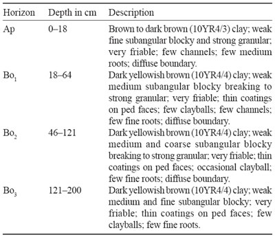
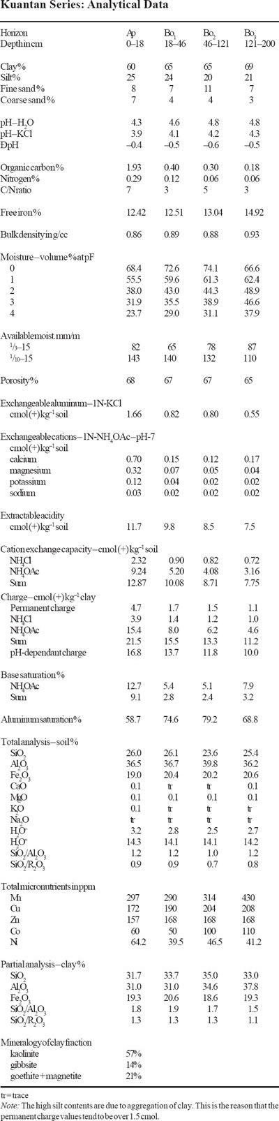
The Kuantan Series is a member of the Kuantan Family which is a very fine, oxidic, isohyperthermic, brown Tipik Akrolemoks. It typifies this family and is developed over basalt. These are deep (> 100 cm), very friable and uniformly brown soils having a thin dark brown to brown A horizons and dark yellowish brown clayey B oxic horizons. The depth of these soils often exceeds two metres below which iron-coated basalt parent material occurs. The ECEC values are less than 1.5 cmol (+) kg–1 clay in the oxic horizon.
Type Location
The Kuantan Series was first established by Owen (1951) in the vicinity of Kuantan town. The above pedon was described by Paramananthan (1977) at the Bukit Goh Felda Oil Palm Scheme, near Kuantan, Pahang. The elevation was 30 metres (100 ft) and on midslope of a short (8% or 4°) slope in gently undulating terrain. Location: Topographic Sheet 4360, 3°55′ N, 103°15’40” E (Grid reference 4360 – 855325 m).
Range in Characteristics
The range in characteristics of the Kuantan Series has been outlined by Paramananthan and Lim (1974). The A horizon is often a thin dark brown (10YR4/3) clay while the B horizons which are uniform and deep have colours ranging from dark yellowish brown to dark brown through to reddish brown (10YR4/4, 7.5YR4/4 and 5YR4/4) with clay textures. The structures are generally very weak subangular blocky breaking readily to strong granules. The soils have extremely friable consistence and clayballs are often found in the profile. Drainage is somewhat excessive. The profiles are usually very deep and almost always exceed two metres in depth. Below this depth the soil changes abruptly to yellowish red iron coated parent material. Sometimes a band of loosely packed petroplinthite gravels occur at depth above the basalt.
Competing Soils and Their Differences
The Kuantan Series is at an advanced stage of weathering and therefore tends to resemble other soils at a similar stage. The soils which are fairly similar include Sungei Mas Series and Senai Series. The Sungei Mas Series is fairly similar to the Kuantan Series. The Kuantan Series in general has much yellower hues than the Sungei Mas Series. The Kuantan Series is derived from basic lavas (or tuffs) while the Sungei Mas Series on serpentinite. Occasionally the Kuantan Series (on steeper slopes) develops yellowish red colours. The Senai Series has higher values and chromas and is developed over gabbro parent material. The Tangga Series described by Lim (1976) belongs to the same family but is developed over limestone. The Table Series mapped in Sabah over basalts has a morphology similar to that of the Kuantan Series but generally has higher cation exchange capacity values. The Pinianakan Series mapped in Sabah over serpentinites has dusky red colours and higher cation exchange capacity values. The Goh Series mapped locally in the Jabor Valley area in Pahang is the moderately deep (50– 100 cm) equivalent of the Kuantan Series.
Setting
The Kuantan Series typically occurs on gently undulating terrain (4–20% or 2– 10° slopes) over the Quaternary basalts (1.6 My) in the vicinity of Kuantan. They occur at elevations not exceeding 150 metres (450 ft).
Principal Associated Soils
In the Kuantan area, where these soils have only been mapped to-date, they occur as distinctive soils easily distinguished from other soils such as Rengam Series, Bungor Series etc. in the surrounding area. Therefore they have only been mapped as a single series and never in association. In detailed mapping the Kuantan Series is locally associated with its moderately deep equivalent the Goh Series and the shallow equivalent the Jabor Series.
Drainage and Permeability
The soils of the Kuantan Series have very rapid permeability and very rapid internal drainage. They are somewhat excessively drained soils.
Use and Vegetation
Except for a small area in the Bukit Goh Forest Reserve which is under Lowland Dipterocarp Forest most of the areas under the Kuantan Series have been developed for agriculture. The common crops are fruit trees, rubber, and oil palm which are mainly under estate management and some under smallholders.
Distribution and Extent
The Kuantan Series has only been mapped in the vicinity of Kuantan town in Pahang. They are estimated to occupy about 18,000 ha. They are found in the Bukit Goh Forest Reserve, Bukit Goh Felda Schemes and in Jabor Valley and a little in southern Terengganu.
Series Established
This soil was established near Kuantan, Pahang by Owen (1951). The source of name is Kuantan town in Pahang, Peninsular Malaysia.
Remarks on Classification
The Kuantan Series is classified here according to the Malaysian Soil Taxonomy – Second Approximation (Paramananthan 1998) as a member of the very fine, oxidic, isohyperthermic, brown family of Tipik Akrolemoks which is developed over basalts. They are classified here as soils having a deep oxic horizon, heavy clay texture, weak structures and a low (< 1.5 cmol (+) kg–1 clay) cation retention capacity in the B horizon. In the Keys to Soil Taxonomy – Eighth Edition (Soil Survey Staff 1998) these soils would be classified as Typic Hapludox as they do not meet the pH requirement of the Acrudox. In the FAO/UNESCO Soil Map of the World – Revised Legend (FAO 1990) the Kuantan Series would probably be classified as Geric Ferralsols.
Suitability for Agriculture
The somewhat excessive drainage can be a serious limitation to the agricultural potential of the soil. Oil palm yields can be expected to fluctuate significantly with periods of drought. Moisture, P fixation and low nutrient content are expected to be the major limitations of this soil. The establishment of the cover crops and the main crops is difficult particularly if droughts are encountered. Once established, rooting is deep and moisture is not expected to be that serious a problem.
Soil Profiles: Katong
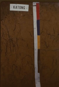
Katong Series
The Katong Series is a member of the Munchong Family which is a very fine, kaolinitic, isohyperthermic, red-yellow Tipik Tempalemoks. It is developed over quartz diorite or quartz andesite parent material. The soils have brown to dark brown fine sandy clay loam A horizons and yellowish brown to strong brown clayey B horizons. The soils occur on rolling to hilly and steep terrain and are often deep but pieces of weathered quartz andesite or trachyandesitic tuff may be encountered at depths below one metre.

Type Location
The Katong Series was established in the Ulu Tembeling District of north-east Pahang by Libby (1964). The above pedon was described at a hill cutting at the 1133/ milestone Jerantut-Temerloh road. The pedon was described by Law (1964) on a 14° slope in hilly terrain. Location: Topographic Sheet 4060, 3°51’55” N, 102°23′ E (Grid Reference 4060 – 877273 m).
Range in Characteristics
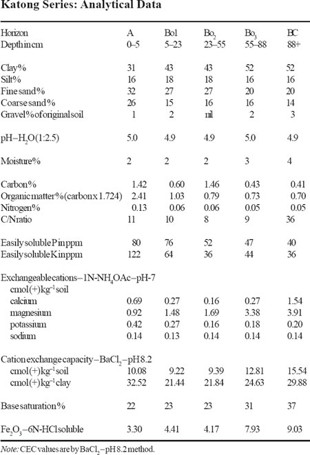
The A horizon is often a brown to dark brown (7.5YR4/5, 10YR4/3) with fine sandy clay loam or clay loam textures. The oxic B horizons are often uniform to depths of one metre. They range in colours from yellowish brown to strong brown (10YR5/6 to 7.5YR5/6–5/8) in the major part of the B horizon. At depths the colours become yellowish red (5YR5/8) with medium distinct red mottles. Textures are clayey with about 40–80% clay and about 20% fine sand. The structures are moderate medium subangular blocky and consistence friable. Often thin patchy coatings are found on ped faces possibly indicating degraded clayskins. Occasionally a few petroplinthite concretions occur in the profile. At depth below one metre (depending on the slope) pieces of weathered rock fragments occur in the profile.
Competing Soils and Their Differences
The predominantly browner hues of the Katong Series makes the soil resemble soils such as Munchong Series and Jerangau Series. It is quite easily distinguished from the other Oksanah such as Segamat Series, Senai Series and Sungei Mas Series. Admittedly it is quite difficult to distinguish the Katong Series from the Munchong Series and Jerangau Series. The Munchong Series is derived from iron rich shale and has slightly weaker structures while the Jerangau Series is derived from granodiorite may be slightly more sandy. The Jerangau Series also has an ECEC of less than 1.5 cmol (+) kg–1 clay. One other feature which many be used is the fact that the Katong Series is developed over andesite, andesitic tuffs and trachyandesitic tuffs and is often closely associated with the Segamat Series while the Munchong Series occurs in areas of sedimentary rocks. The Katong Series is also often a shallower soil and is predominantly mapped on hilly to steep slopes (24–50% or 12–15° slopes)
Setting
The Katong Series soils occur typically on somewhat steep terrain (24–50% or 12–25° slopes). The depth of the profile is often closely related to the slope – being shallower on the steeper slopes. The soils are commonly only about a metre (3 feet) deep where pieces of weathered rock fragments are encountered. They occur at elevations not exceeding 100 metres (300 ft) although they may occur on higher altitudes which have not been surveyed to-date.
Principal Associated Soils
The Katong Series has been mapped in association with the Segamat Series. In the past the distinction between Segamat and Katong has not been well defined. This is particularly true where the colours are strong brown. In the redefinition here a soil would be Katong where 7.5YR hues or yellower dominate the upper part of the profile to a depth of at least 50 cm i.e. the Katong Series may only have 5YR hues below 50 cm depth. The soils of the Segamat Series would therefore have redder hues, heavier textures and weaker structures and a lower ECEC.
Drainage and Permeability
The Katong Series is a well drained soil. Permeability is good.
Use and Vegetation
The soils of the Katong Series have been mainly planted with rubber and oil palm. Rubber is by far the dominant crop on the steeper slopes. In Pahang and north Johore some of the areas with these soils are still under primary Lowland Dipterocarp Forest.
Distribution and Extent
Like the Segamat Series the Katong Series is closely associated with the belt of the volcanic tuffs and lavas referred to as the Pahang Volcanic Series. These soils to-date have only been mapped in Central Pahang – in the Jengka Triangle, Ulu Tembeling and around Jerantut and in north Johore. It is estimated that these soils occupy about 32,000 ha (80,000 acres) of the areas having slopes of less than 38% (20°). With the redefinition used above the extent of the Katong Series may be greater.
Series Established
This soils was established during the Reconnaissance Soil Survey of North-East Pahang Libby (1964) in the Lepar Valley in Pahang. The source of name is Sungei Katong, Pahang.
Remarks on Classification
The Katong Series is classified here according to the Malaysian Soil Taxonomy – Second Approximation (Paramananthan 1998) as a member of the very fine, kaolinitic, isohyperthermic, red-yellow family of the Tipik Tempalemoks. They are classified here as soils with an oxic horizon which has moderate structures and an ECEC of more than 1.5 cmol (+) kg–1 clay. It must be pointed out here that the pedon and the analytical data used in this paper were made a long time ago. In particular the analytical methods are not those as required in the Malaysian Soil Taxonomy and care must be taken when interpreting these results. The classification offered here therefore is somewhat tentative until better data is available. In the Keys to Soil Taxonomy – Eighth Edition (Soil Survey Staff 1998) the Katong Series would probably be Typic Hapludox. In the FAO/UNESCO Soil Map of the World – Revised Legend (FAO 1990) the Katong Series would be classified as Haplic Ferralsols.
Suitability for Agriculture
The most serious limiting factor of this soil is the terrain and the depth of soil. The soil is also well drained and hence moisture can be a problem if droughts occur in the area. Rubber is probably the best crop on these soils. Fruit trees may also do well on these soils.
Soil Profiles: Jawa
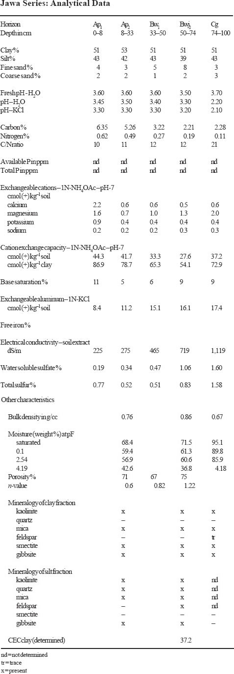
Jawa Series
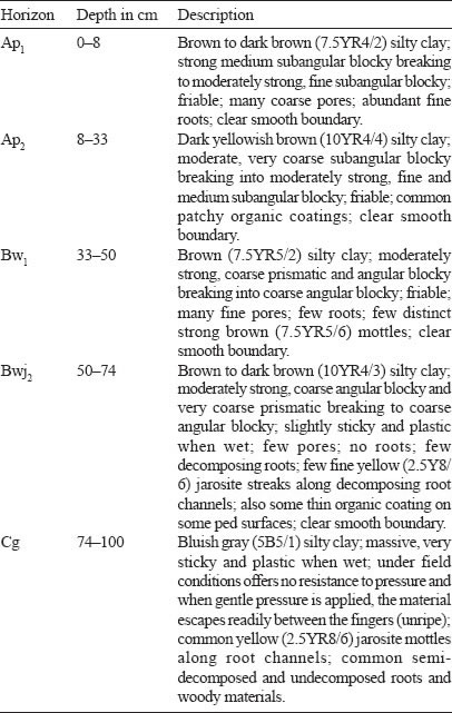
The Jawa Series is a member of the Jawa Family which is a fine, mixed, isohyperthermic, brown Sulfik Tempajelahs. It typifies this family which is developed over brackish water deposits. These soils have a brown to dark brown silty clay surface horizons which grades into a yellowish brown to brown silty clay B horizons having moderate medium and fine subangular blocky structures and friable consistence. In the lower part of the B horizon below 50 cm depth a sulfuric horizon with jarosite mottles occurs. The bluish gray to grey massive marine clay which is unripe occurs below the sulfuric horizon. In this C horizon jarosite mottles may occur along old root traces.
Type Location
The Jawa Series was first established by Paramananthan (1975) during the survey of Phase I of Johor Barat. Such soils were earlier mapped as Selangor Series shallow phase. The above pedon was described by Noordin Daud (1980) on Sabrang Estate south of Telok Anson, Perak. Location: Topographic Sheet 3460, 4°01’50” N, 100°56’20” E (Grid Reference 3460 – 292463 m).
Range in Characteristics
The Jawa Series may have a surface horizon which is organic but it does not exceed 20 cm and very often the material is sapric. Like many of the other man-made soils, the degree of decomposition depends on the intensity and the length of time the area has been drained. However very often the surface horizon is mineral. The A horizons in the Jawa Series range in colour from black to dark brown, dark grayish brown to dark gray (10YR2/1, 3/3, 4/1, 4/2, 4/3; 7.5YR3/ 2, 4/2, 4/4) and are humic clay, silty clay or clay with moderate to strong medium and fine subangular blocky structures. The B horizons are usually dark brown, brown, dark grayish brown to grayish brown (10YR3/3, 4/2, 4/3, 5/2, 5/3 and 7.5YR4/2) silty clay to clay often rich in organic carbon. Structures in the upper part of the B horizon depending on the drainage ranges from weak coarse angular blocky to strong, medium and fine subangular blocky. Below 50 cm the grade of structure decreases and becomes weak to moderate medium to coarse angular blocky or even prismatic. Consistence is friable in the upper part of the soil but becomes sticky with depth. Mottling is mainly confined to old root channels and ranges from common fine to medium, distinct strong brown (7.5YR5/6–5/8) and few fine distinct reddish yellow (7.5YR6/6–6/8). Below 50 cm depth yellow (2.5Y8/6) jarosite mottles occur mainly along old root traces. The underlying unripe marine deposit is a greenish gray, dark greenish gray or bluish gray (5GY4/1, 5/1, 6/1, 5G4/1, 5/1, 6/1; 5BG4/1, 5/1, 6/1) silty clay to clay which may or may not have jarosite mottles along old root channels. This marine deposit may be encountered either within 100 cm or below 100 cm. Some buried wood is a common feature in this deposit.
Competing Soils and Their Differences
The Jawa Series may be confused with soils of the Sedu, Parit Botak, Tongkang (A), Perepat, Sabrang and Selangor Series. The Sedu and Parit Botak Series have a sulfuric horizon within 50 cm while the Jawa Series between 50 to 100 cm. The Tongkang Series also has a sulfuric horizon between 50 and 100 cm but it has light gray matrix colours, coarser structures and sticky consistence. Both the Perepat and Sabrang Series do not have a sulfuric horizon. The Perepat Series also has light gray colours. The Sabrang Series has almost all features similar to that of the Jawa Series except that a sulfuric horizon is not present in the case of the Sabrang Series. The Jawa Series which have the marine clay below one metre may be confused with that of the Selangor Series because both have friable, brown B horizons. However the Selangor Series either does not have jarosite or if present the sulfuric horizon only occurs below one metre. The underlying marine clay of the Jawa Series is often sulfidic but even if it was not sulfidic the soil is currently placed with the Jawa Series due to the overlying sulfuric horizon. No true acid sulfate soils have been mapped in Sabah and Sarawak to-date as potential acid sulfate soils have only been recently drained. In Sabah, soils of the Bergosong Family (Thionic-Humic Gleysols) when drained may developed into the Jawa Series if the sulfuric horizon occurs between 50–100 cm depth. In Sarawak, soils of the Kluang Series are only potential acid sulfate soils with sulfidic materials between 50–100 cm depth. More data is required to correlate these soils.
Setting
Soils of the Jawa Series form a sequence with soils of the Sedu and Selangor Series. The Sedu Series is characterized by having a sulfuric horizon within 50 cm of the surface while the Jawa between 50 to 100 cm and the Selangor does not have a sulfuric horizon to 100 cm. These soils occur in areas on the coastal plain where they grade into a peat swamp.
Principal Associated Soils
The Jawa Series since it forms a sequence with the Selangor and Sedu Series is often associated with both these soils. These three soils only differ in the depth at which the sulfuric horizon occurs. The Jawa Series may often also be associated with other non-acid sulfate soils such as the Serkat and Sabrang Series. Both these soils only have a cambic horizon overlying the marine clay at different depths.
Drainage and Permeability
The Jawa Series soils are somewhat poorly drained soils. They often have the permanent groundwater table around 50–100 cm. Above this marine clay horizon the B horizon has fairly good permeability.
Use and Vegetation
The Jawa Series is a man-made soil as it is formed by artificial drainage. These soils have been mapped in the past as Selangor Series (shallow phase). These soils are currently cultivated to oil palm, coconut, cocoa, and coffee. Although pineapple, coffee and rubber may have been planted in the past these are slowly being replaced with oil palm.
Distribution and Extent
Most of the areas mapped as Selangor (shallow) have now been reclassified into many soils including the Jawa, Sedu, Serkat and Sabrang Series. It is therefore difficult at this stage to determine the actual extent of these soils. These soils have to-date been identified in the Kerian and Telok Anson areas of Perak, in Selangor, in Malacca, Johor and also in Pahang.
Series Established
The Jawa Series was first established during the semi-detailed soil survey of Johor Barat. The source of the name is the village of Parit Jawa, in Johor.
Remarks on Classification
The Jawa Series is classified here according to the Malaysian Soil Taxonomy – Second Approximation (Paramananthan 1998) as a member of the fine, mixed, isohyperthermic, brown family of SULFIK TEMPAJELAH. These are poorly drained soils which have brown coloured B horizons and a sulfuric horizon between 50 to 100 cm depth. In the Keys to Soil Taxonomy – Eighth Edition (Soil Survey Staff 1998) the Jawa Series would probably be classified as Sulfic Endoaquepts. In the FAO/ UNESCO Soil Map of the World – Revised Legend (FAO 1990) this soil would be classified as Thionic Fluvisols.
Suitability for Agriculture
Crops which only require about 50 cm of soil such as cash crops can be readily cultivated on this soil. Oil palm can also be grown on this soil with good management – especially water control to keep the sulfuric horizon moist. Coconut and coffee should also do well on these soils. Cocoa however is only expected to be marginal on these soils.